Natura 2000 related content is now shown on the Biodiversity Information System for Europe, BISE. Please go to BISE or use the Natura 2000 map viewer for the latest information.

Decalcified fixed dunes with Empetrum nigrum

Description (English)

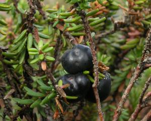
Decalcified dunes colonised by Empetrum nigrum heaths, of the German, Danish, Scottish, Finnish, Swedish and Dutch (Friesian) coasts. Syntaxa associated to this habitat type: Empetrion nigri, Calluno Genistion pilosae p., Ericion tetralicis p.
The term "fixed" should be taken to mean the opposite of "shifting". The psychrophilic coastal association Carici trinervis-Callunetum vulgaris de Foucault & Gehu 1978 may be included here.

Source: Interpretation Manual of European Union Habitats, version EUR 28 (2013)

Quick facts

EU Habitats Directive Annex I habitat type (code 2140)
Habitat type Priority
Natura 2000 sites 116 are designated for this habitat type

Distribution

The distribution map is currently disabled. A new map solution will soon become available. In the meantime, please consult other species distribution map providers listed in the Other resources panel below.

Conservation status

EU conservation status

Conservation status assesses every six years and for each biogeographical region the condition of habitats and species compared to the favourable status as described in the Habitats Directive. The map shows the 2013-2018 assessments as reported by EU Member State. Assessments are further detailed in the summary document available behind the link below.

Good: A habitat is in a situation where it is prospering and with good prospects to do so in the future as well
Poor: A habitat is in a situation where a change in management or policy is required to return the habitat to favourable status but there is no danger of disappearance in the foreseeable future
Bad: A habitat is in serious danger of disappearing (at least regionally)
Unknown: The information available for the habitat type is scarce and does not allow a proper assessment of its conservation status

Species mentioned in habitat description

Flowering Plants Carex arenaria
Flowering Plants Empetrum nigrum
Flowering Plants Genista tinctoria
Flowering Plants Pyrola rotundifolia
Species scientific name English common name Species group
Carex arenaria Flowering Plants
Empetrum nigrum Flowering Plants
Genista tinctoria Flowering Plants
Pyrola rotundifolia Flowering Plants

Natura 2000 sites

Protected in the following Natura 2000 sites

Sitecode Country Site name Action
DE0916391 Germany NTP S-H Wattenmeer und angrenzende Küstengebiete Map
DE0916392 Germany Dünen- und Heidelandschaften Nord-Sylt Map
DE1016392 Germany Dünen- und Heidelandschaften Nord- und Mittel-Sylt Map
DE1115391 Germany Dünenlandschaft Süd-Sylt Map
DE1116391 Germany Küstenlandschaft Ost-Sylt Map
DE1315391 Germany Küsten- und Dünenlandschaften Amrums Map
DE1541301 Germany Darß Map
DE1544302 Germany Westrügensche Boddenlandschaft mit Hiddensee Map
DE1617301 Germany Dünen St. Peter Map
DE2117331 Germany Küstenheiden und Krattwälder bei Cuxhaven Map
DE2306301 Germany Nationalpark Niedersächsisches Wattenmeer Map
DK003X206 Denmark Rusland Map
DK003X208 Denmark Tisvilde Hegn og Melby Overdrev Map
DK005X221 Denmark Sejerø Bugt og Saltbæk Vig Map
DK005Y220 Denmark Havet og kysten mellem Hundested og Rørvig Map
DK005Y229 Denmark Skælskør Fjord og havet og kysten mellem Agersø og Glænø Map
DK006X233 Denmark Havet og kysten mellem Præstø Fjord og Grønsund Map
DK007X246 Denmark Dueodde Map
DK008X184 Denmark Æbelø, havet syd for og Nærå Map
DK00AX172 Denmark Blåbjerg Egekrat, Lyngbos Hede og Hennegårds Klitter Map
DK00AX173 Denmark Kallesmærsk Hede, Grærup Langsø, Fiilsø og Kærgård Klitplantage Map
DK00AY176 Denmark Vadehavet med Ribe Å, Tved Å og Varde Å vest for Varde Map
DK00CX160 Denmark Nissum Fjord Map
DK00CX161 Denmark Stadil Fjord og Vest Stadil Fjord Map
DK00CX278 Denmark Husby klit Map
DK00CY040 Denmark Venø, Venø Sund Map
DK00CY163 Denmark Ringkøbing Fjord og Nymindestrømmen Map
DK00DX146 Denmark Anholt og havet nord for Map
DK00DX151 Denmark Begtrup Vig og kystområder ved Helgenæs Map
DK00DX155 Denmark Stavns Fjord, Samsø Østerflak og Nordby Hede Map
DK00DX300 Denmark Mols Bjerge med kystvande Map
DK00DY156 Denmark Horsens Fjord, havet øst for og Endelave Map
DK00EX017 Denmark Ålvand Klithede og Førby Sø Map
DK00EX025 Denmark Vangså Hede Map
DK00EX129 Denmark Vullum Sø Map
DK00EX130 Denmark Hanstholm Reservatet, Nors Sø og Vandet Sø Map
DK00EX132 Denmark Hvidbjerg Å, Ove Sø og Ørum Sø Map
DK00EX265 Denmark Klitheder mellem Stenbjerg og Lodbjerg Map
DK00EX266 Denmark Lild Strand og Lild Strandkær Map
DK00EX268 Denmark Korsø knude Map
DK00EX283 Denmark Hanstholmknuden Map
DK00EY124 Denmark Løgstør Bredning, Vejlerne og Bulbjerg Map
DK00EY133 Denmark Agger Tange, Nissum Bredning, Skibsted Fjord og Agerø Map
DK00EY134 Denmark Lovns Bredning, Hjarbæk Fjord og Skals, Simested og Nørre Ådal, Skravad Bæk Map
DK00FX005 Denmark Råbjerg Mile og Hulsig Hede Map
DK00FX010 Denmark Strandenge på Læsø og havet syd herfor Map
DK00FX112 Denmark Skagens Gren og Skagerak Map
DK00FX114 Denmark Uggerby Klitplantage og Uggerby Å's udløb Map
DK00FX118 Denmark Holtemmen, Højsande og Nordmarken Map
DK00FX119 Denmark Solsbæk Map
DK00FX121 Denmark Svinkløv Klitplantage og Grønne Strand Map
DK00FX122 Denmark Ålborg Bugt, Randers Fjord og Mariager Fjord Map
DK00FX125 Denmark Lille Vildmose, Tofte Skov og Høstemark Skov Map
DK00FX274 Denmark Ejstrup klit og Egvands Bakker Map
DK00FX317 Denmark Lien med Underlien Map
DK00FX342 Denmark Jerup Hede, Råbjerg og Tolshave Mose Map
EE0010126 Estonia Prangli Map
EE0010171 Estonia Kolga lahe Map
EE0010173 Estonia Lahemaa Map
EE0040201 Estonia Nõva-Osmussaare Map
FI0100005 Finland Tammisaaren ja Hangon saariston ja Pohjanpitäjänlahden merensuojelualue Map
FI0100006 Finland Tulliniemen linnustonsuojelualue Map
FI0200090 Finland Saaristomeri Map
FI0200111 Finland Paraisten harjusaaret Map
FI0408001 Finland Itäisen Suomenlahden saaristo ja vedet Map
FI0800133 Finland Uudenkaarlepyyn saaristo Map
FI0800134 Finland Kristiinankaupungin saaristo Map
FI0800135 Finland Närpiön saaristo Map
FI1000017 Finland Vattajanniemi Map
FI1100201 Finland Hailuoto, pohjoisranta Map
FI1102200 Finland Liminganlahti Map
FI1105202 Finland Siikajoen lintuvedet ja suot Map
FI1300302 Finland Perämeren saaret Map
IE0000164 Ireland Lough Nagreany Dunes SAC Map
IE0000190 Ireland Slieve Tooey/Tormore Island/Loughros Beg Bay SAC Map
IE0000194 Ireland Tranarossan and Melmore Lough SAC Map
IE0000197 Ireland West of Ardara/Maas Road SAC Map
IE0001141 Ireland Gweedore Bay and Islands SAC Map
LTNER0005 Lithuania Kuršių nerija Map
LV0200200 Latvia Kemeru nacionalais parks Map
LV0200300 Latvia Sliteres nacionalais parks Map
LV0303500 Latvia Pape Map
LV0520300 Latvia Uzava Map
LV0521500 Latvia Ovisi Map
LV0528300 Latvia Gipka Map
LV0536500 Latvia Pavilostas peleka kapa Map
NL1000009 Netherlands Duinen Den Helder - Callantsoog Map
NL1000010 Netherlands Schoorlse Duinen Map
NL1000012 Netherlands Kennemerland-Zuid Map
NL2003059 Netherlands Duinen Terschelling Map
NL2003060 Netherlands Duinen en Lage Land Texel Map
NL2003061 Netherlands Duinen Vlieland Map
NL3000016 Netherlands Zwanenwater & Pettemerduinen Map
NL3009005 Netherlands Duinen Ameland Map
NL9801080 Netherlands Noordhollands Duinreservaat Map
PLH220003 Poland Białogóra Map
PLH220018 Poland Mierzeja Sarbska Map
PLH220023 Poland Ostoja Słowińska Map
PLH220032 Poland Zatoka Pucka i Półwysep Helski Map
PLH320019 Poland Wolin i Uznam Map
SE0210212 Sweden Billudden Map
SE0420232 Sweden Bjärekusten Map
SE0420233 Sweden Ängelholms kronopark Map
SE0430082 Sweden Möllehässle-Kullens havsbad Map
SE0430095 Sweden Falsterbohalvön Map
SE0430111 Sweden Falsterbo skjutfält Map
SE0430151 Sweden Domsten-Viken Map
SE0510006 Sweden Laholmsbuktens sanddynsreservat Map
SE0510020 Sweden Haverdal Map
SE0510039 Sweden Grimsholmen Map
SE0630089 Sweden Hölick Map
SE0630182 Sweden Oxsand Map
SE0810034 Sweden Bjuröklubb Map
SE0810035 Sweden Skötgrunnan Map
SE0810431 Sweden Storsand Map
SE0810453 Sweden Killingsanden Map

Protected sites

Please note the site map takes a while to display.

Relation to habitat classifications

Classification Code Habitat type name Relationship type
Nordic Vegetation Classification 1994 4.1.4.3 Calluna vulgaris-Empetrum nigrum-Carex arenaria-typ not defined
National Vegetation Classification (UK) H11b Calluna vulgaris-Carex arenaria heath community, Empetrum nigrum ssp. nigrum sub-community not defined
German Federal List of Biotopes 100401 Krähenbeer-Heide der Küsten not defined
European Environment Agency (EEA)
Kongens Nytorv 6
1050 Copenhagen K
Denmark
Phone: +45 3336 7100