Kingdom: Animalia > Phylum: Chordata > Class: Aves > Order: Anseriformes > Family: Anatidae > Genus: Anas > Species: Anas querquedula

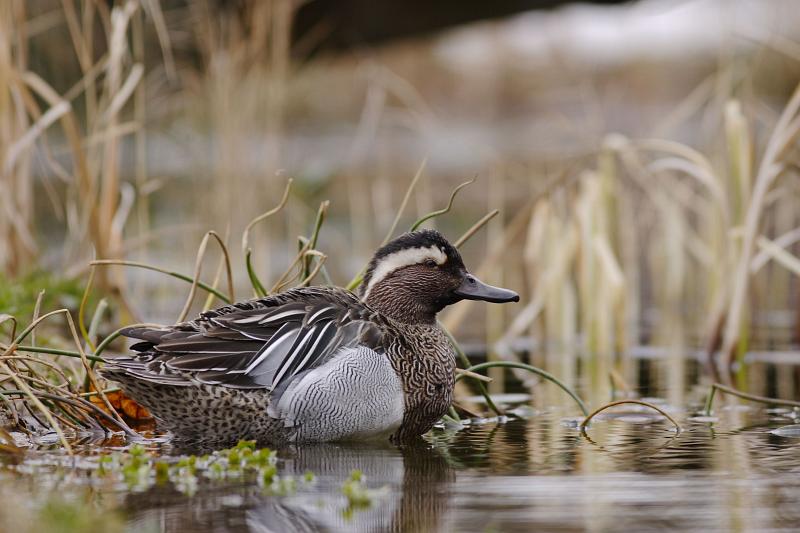
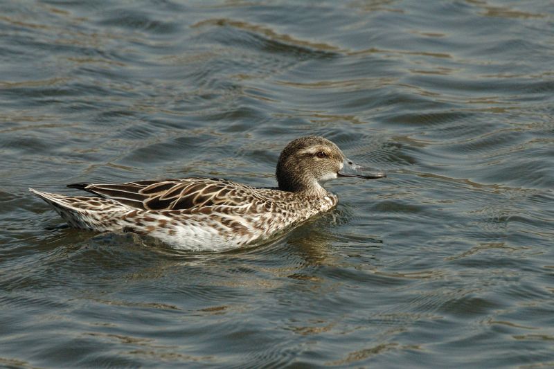
Garganey - Anas querquedula Linnaeus, 1758

Images from the web

Quick facts

Threat status Europe Least Concern (IUCN)
Protected by EU Birds Directive and 4 other international agreements
Natura 2000 sites 1272 are designated for this species
Breeding habitats
  • rivers and lakes
  • wetlands
Wintering habitats
  • marine inlets and transitional waters

Distribution

The distribution map is currently disabled. A new map solution will soon become available. In the meantime, please consult other species distribution map providers listed in the Other resources panel below.

Threat and conservation status

IUCN Red List status of threatened species

The IUCN Red List threat status assesses the risk of extinction.

IUCN Red List Category
Not Evaluated
Near Threatened
Regionally Extinct
Not Applicable
Vulnerable
Extinct in the Wild
Data Deficient
Endangered
Extinct
Least Concern
Critically Endangered

EU conservation status

The EU conservation status is assessed for species mentioned in the EU Habitats Directive annexes. The EU Habitats Directive does not cover this species.

Natura 2000 sites

Protected in the following Natura 2000 sites

Sitecode Country Site name Action
BE31004C0 Belgium Vallée de la Dyle en aval d'Archennes Map
BE32046C0 Belgium Vallée du Piéton Map
BE33064C0 Belgium Vallée de l'Ulf Map
BE35001A0 Belgium Etangs de Boneffe Map
BE35007C0 Belgium Forêts et lac de Bambois Map
CY6000002 Cyprus ALYKES LARNAKAS Map
DE1119401 Germany Gotteskoog-Gebiet Map
DE1727401 Germany Lanker See Map
DE1728401 Germany Teiche zwischen Selent und Plön Map
DE2021401 Germany NSG Kudensee Map
DE2030303 Germany NSG Aalbeek-Niederung Map
DE2121401 Germany Unterelbe Map
DE2210401 Germany Niedersächsisches Wattenmeer und angrenzendes Küstenmeer Map
DE2508401 Germany Krummhörn Map
DE2509401 Germany Ostfriesische Meere Map
DE2526402 Germany Untere Seeve- und Untere Luhe-Ilmenau-Niederung Map
DE2609401 Germany Emsmarsch von Leer bis Emden Map
DE2611401 Germany Fehntjer Tief Map
DE2617401 Germany Unterweser Map
DE2709401 Germany Rheiderland Map
DE2719401 Germany Hammeniederung Map
DE2746401 Germany Uckermärkische Seenlandschaft Map
DE2752302 Germany Salveytal Map
DE2816401 Germany Hunteniederung Map
DE2819402 Germany Borgfelder Wümmewiesen Map
DE2820402 Germany Wümmewiesen bei Fischerhude Map
DE2832401 Germany Niedersächsische Mittelelbe Map
DE2918401 Germany Niedervieland Map
DE2935401 Germany Aland-Elbe-Niederung Map
DE2948401 Germany Schorfheide-Chorin Map
DE2951401 Germany Unteres Odertal Map
DE3036401 Germany Unteres Elbtal Map
DE3222401 Germany Untere Allerniederung Map
DE3239401 Germany Untere Havel/Sachsen-Anhalt und Schollener See Map
DE3334401 Germany Milde-Niederung/Altmark Map
DE3339402 Germany Niederung der Unteren Havel Map
DE3341401 Germany U. Rhinluch/Dreetzer See, Havell. Luch und Belziger Landschaftsw. Map
DE3415401 Germany Dümmer Map
DE3418401 Germany Diepholzer Moorniederung Map
DE3431401 Germany Drömling Map
DE3437401 Germany Elbaue Jerichow Map
DE3444401 Germany Döberitzer Heide Map
DE3450401 Germany Märkische Schweiz Map
DE3513401 Germany Alfsee Map
DE3519401 Germany Vogelschutzgebiet 'Weseraue' Map
DE3521401 Germany Steinhuder Meer Map
DE3530401 Germany Barnbruch Map
DE3532401 Germany Vogelschutzgebiet Drömling Map
DE3540301 Germany Große Freiheit bei Plaue Map
DE3612401 Germany Vogelschutzgebiet 'Düsterdieker Niederung' Map
DE3618401 Germany Vogelschutzgebiet 'Bastauniederung' Map
DE3642401 Germany Rietzer See Map
DE3727401 Germany Lengeder Teiche Map
DE3807401 Germany Vogelschutzgebiet 'Moore und Heiden des westlichen Münsterlandes' Map
DE3828401 Germany Heerter See Map
DE3911401 Germany Vogelschutzgebiet 'Rieselfelder Münster' Map
DE4108401 Germany VSG 'Heubachniederung, Lavesumer Bruch und Borkenberge' Map
DE4116401 Germany VSG 'Rietberger Emsniederung mit Steinhorster Becken' Map
DE4137401 Germany Wulfener Bruch und Teichgebiet Osternienburg Map
DE4139401 Germany Mittlere Elbe einschließlich Steckby-Lödderitzer Forst Map
DE4142401 Germany Mündungsgebiet der Schwarzen Elster Map
DE4152302 Germany Peitzer Teiche Map
DE4203401 Germany Vogelschutzgebiet 'Unterer Niederrhein' Map
DE4225401 Germany Leinetal bei Salzderhelden Map
DE4240301 Germany Mittlere Oranienbaumer Heide Map
DE4531401 Germany Helmestausee Berga-Kelbra (Anteil Sachsen-Anhalt) Map
DE4531403 Germany Kyffhäuser - Badraer Schweiz - Helmestausee Map
DE4536401 Germany Salziger See und Salzatal Map
DE4603401 Germany Vogelschutzgebiet 'Schwalm-Nette-Platte mit Grenzwald u. Meinweg' Map
DE4638401 Germany Saale-Elster-Aue südlich Halle Map
DE4820401 Germany Stausee von Affoldern Map
DE4831301 Germany Unstrut-Niederung nordöstlich Herbsleben Map
DE4831401 Germany Gera-Unstrut-Niederung um Straußfurt Map
DE4940301 Germany Haselbacher Teiche und Pleißeaue Map
DE5024301 Germany Forbachsee bei Bebra Map
DE5038303 Germany Brahmeaue Map
DE5237301 Germany NSG Frießnitzer See - Struth Map
DE5314303 Germany NSG Krombachtalsperre Map
DE5336302 Germany Dreba-Plothener Teichgebiet Map
DE5336401 Germany Plothener Teiche Map
DE5412401 Germany Westerwälder Seenplatte Map
DE5511301 Germany NSG Urmitzer Werth Map
DE5511401 Germany Engerser Feld Map
DE5707401 Germany Jungferweiher Map
DE5723302 Germany Westerngrund von Neuengronau und Breunings Map
DE5807401 Germany NSG Sangweiher und Erweiterung Map
DE5818401 Germany Main bei Mühlheim und NSG 'Rumpenheimer und Bürgeler Kiesgruben' Map
DE5819308 Germany Erlensee bei Erlensee und Bulau bei Hanau Map
DE5820302 Germany Weideswiesen-Oberwald bei Erlensee Map
DE6013401 Germany Rheinaue Bingen-Ingelheim Map
DE6013403 Germany NSG Hinter der Mortkaute Map
DE6016302 Germany NSG Kisselwörth und Sändchen Map
DE6017304 Germany Mönchbruch von Mörfelden u.Rüsselsheim u.Gundwiesen von Mörfelden Map
DE6019303 Germany Untere Gersprenz Map
DE6116301 Germany Riedwiesen von Wächterstadt Map
DE6216401 Germany Eich-Gimbsheimer Altrhein Map
DE6315401 Germany Klärteiche Offstein Map
DE6316401 Germany Lampertheimer Altrhein Map
DE6341301 Germany Torflohe Map
DE6416401 Germany Bobenheimer und Roxheimer Altrhein mit Silbersee Map
DE6516401 Germany Neuhofener Altrhein mit Prinz-Karl-Wörth Map
DE6716404 Germany Heiligensteiner Weiher Map
DE6717401 Germany Wagbachniederung Map
DE6816404 Germany Sondernheimer Tongruben Map
DE7243402 Germany Isarmündung Map
DE7322401 Germany Grienwiesen und Wernauer Baggerseen Map
DE7537401 Germany Naturschutzgebiet 'Vogelfreistätte Mittlere Isarstauseen' Map
DE7624402 Germany Schmiechener See Map
DE8025401 Germany Wurzacher Ried Map
DE8220401 Germany Untersee des Bodensees Map
DE8323401 Germany Eriskircher Ried Map
EE0010170 Estonia Paljassaare Map
EE0040001 Estonia Väinamere Map
EE0040346 Estonia Pärnu lahe Map
EE0040351 Estonia Luitemaa Map
EE0040412 Estonia Kahtla-Kübassaare Map
EE0040418 Estonia Kasti lahe Map
EE0040469 Estonia Siiksaare-Oessaare Map
EE0080172 Estonia Endla Map
EE0080271 Estonia Räpina poldri Map
EE0080313 Estonia Ropka-Ihaste Map
EE0080374 Estonia Alam-Pedja Map
EE0080571 Estonia Võrtsjärve Map
ES0000004 Spain Lagunas de Villafáfila Map
ES0000011 Spain Monte de El Pardo Map
ES0000013 Spain Tablas de Daimiel Map
ES0000017 Spain CUENCA DE GALLOCANTA Map
ES0000020 Spain Delta de l'Ebre Map
ES0000023 Spain L'Albufera Map
ES0000024 Spain Doñana Map
ES0000025 Spain Marismas del Odiel Map
ES0000027 Spain Laguna de Medina Map
ES0000029 Spain Complejo Endorreico del Puerto de Santa María Map
ES0000030 Spain Complejo Endorreico de Puerto Real Map
ES0000034 Spain Lagunas del Sur de Córdoba Map
ES0000037 Spain Es Trenc - Salobrar de Campos Map
ES0000038 Spain S'Albufera de Mallorca Map
ES0000046 Spain Cabo de Gata-Níjar Map
ES0000048 Spain Punta Entinas-Sabinar Map
ES0000058 Spain el Fondo d'Elx-Crevillent Map
ES0000069 Spain Embalse de Cornalvo y Sierra Bermeja Map
ES0000084 Spain Ses Salines d'Eivissa i Formentera Map
ES0000119 Spain Carrizales y sotos de Aranjuez Map
ES0000134 Spain Embalse de las Cañas Map
ES0000136 Spain ESTEPAS DE BELCHITE - EL PLANERÓN - LA LOMAZA Map
ES0000138 Spain GALACHOS DE LA ALFRANCA DE PASTRIZ, LA CARTUJA Y EL BURGO DE EBRO Map
ES0000140 Spain Bahía de Cádiz Map
ES0000142 Spain Cortados y cantiles de los ríos Jarama y Manzanares Map
ES0000143 Spain Marismas de Santoña, Victoria y Joyel y Ría de Ajo Map
ES0000144 Spain Urdaibaiko itsasadarra / Ría de Urdaibai Map
ES0000161 Spain Laguna de El Hito Map
ES0000191 Spain Embalse del Ebro Map
ES0000205 Spain Lagunas del Canal de Castilla Map
ES0000211 Spain Desembocadura del riu Millars Map
ES0000216 Spain La Nava-Campos Sur Map
ES0000234 Spain S'Albufera des Grau Map
ES0000243 Spain Txingudi Map
ES0000275 Spain Complejo Endorreico de Lebrija-Las Cabezas Map
ES0000289 Spain LAGUNAS Y CARRIZALES DE CINCO VILLAS Map
ES0000290 Spain LA SOTONERA Map
ES0000294 Spain LAGUNA DE SARIÑENA Y BALSA DE LA ESTACIÓN Map
ES0000296 Spain EMBALSE DEL PAS Y SANTA RITA Map
ES0000303 Spain DESFILADEROS DEL RÍO MARTÍN Map
ES0000318 Spain Cabo Busto-Luanco Map
ES0000320 Spain Embalses del centro (San Andrés, la Granda, Trasona y la Furta) Map
ES0000325 Spain Campiña sur - Embalse de Arroyo Conejos Map
ES0000359 Spain Campos de Alba Map
ES0000363 Spain Monteagudo de las Vicarías Map
ES0000398 Spain Llanos y Complejo Lagunar de la Albuera Map
ES0000408 Spain Vegas del Ruecas, Cubilar y Moheda Alta Map
ES1110004 Spain Encoro de Abegondo - Cecebre Map
ES1300007 Spain Marismas de Santoña, Victoria y Joyel Map
ES2110011 Spain Zadorraren sistemako urtegiak / Embalses del sistema del Zadorra Map
ES2110014 Spain Salburua Map
ES2110019 Spain Izki Map
ES2120018 Spain Txingudi-Bidasoa Map
ES2130007 Spain Urdaibaiko itsasertzak eta padurak / Zonas litorales y marismas de Urdaibai Map
ES2200043 Spain Robledales de Ultzama y Basaburua Map
ES4140036 Spain La Nava-Campos Norte Map
ES6110001 Spain Albufera de Adra Map
ES6120014 Spain Laguna de Las Canteras y El Tejón Map
ES6150003 Spain Estero de Domingo Rubio Map
ES6150005 Spain Marismas de Isla Cristina Map
ES6150006 Spain Marismas del Río Piedras y Flecha del Rompido Map
ES6160002 Spain Alto Guadalquivir Map
ES6170001 Spain Laguna de La Ratosa Map
ES6170015 Spain Lagunas de Campillos Map
ES6180002 Spain Complejo Endorreico de La Lantejuela Map
FI0100005 Finland Tammisaaren ja Hangon saariston ja Pohjanpitäjänlahden merensuojelualue Map
FI0100006 Finland Tulliniemen linnustonsuojelualue Map
FI0100011 Finland Läppträsket Map
FI0100024 Finland Medvastö-Stormossen Map
FI0100025 Finland Saltfjärdenin-Tavastfjärdenin lintuvedet Map
FI0100028 Finland Laajalahden lintuvesi Map
FI0100042 Finland Nummi-Pusulan lintuvedet Map
FI0100046 Finland Tuusulanjärven lintuvesi Map
FI0100052 Finland Järvisuo-Ridasjärvi Map
FI0100058 Finland Kotojärvi-Isosuo Map
FI0100062 Finland Vanhankaupunginlahden lintuvesi Map
FI0100065 Finland Mustavuoren lehto ja Östersundomin lintuvedet Map
FI0100072 Finland Kanteleenjärven lintuvesi Map
FI0100074 Finland Porvoonjoen suisto-Stensböle Map
FI0100078 Finland Pernajanlahtien ja Pernajan saariston merensuojelualue Map
FI0100081 Finland Kullafjärdenin lintuvesi Map
FI0100082 Finland Teutjärven ja Suvijärven lintuvedet Map
FI0100092 Finland Matalajärvi Map
FI0100103 Finland VANJÄRVI-LAUKKAMÄKI Map
FI0200026 Finland Harolanlahti Map
FI0200027 Finland Viurilanlahti Map
FI0200029 Finland Suomijärvi Map
FI0200030 Finland Omenajärvi Map
FI0200031 Finland Otajärvi Map
FI0200032 Finland Köyliönjärvi Map
FI0200034 Finland Poosjärvi Map
FI0200035 Finland Inhottujärvi Map
FI0200036 Finland Paimionlahti Map
FI0200037 Finland Tapilanlahti Map
FI0200039 Finland Niemijärvi - Itäjärvi Map
FI0200040 Finland Kolkanaukko Map
FI0200041 Finland Kulju Map
FI0200044 Finland Lautvesi Map
FI0200058 Finland Kuusistonlahti Map
FI0200060 Finland Rauvolanlahti Map
FI0200072 Finland Uudenkaupungin saaristo Map
FI0200076 Finland Pooskerin saaristo Map
FI0200079 Finland Kokemäenjoen suisto Map
FI0200083 Finland Kiskonjoen vesistö Map
FI0200089 Finland Mietoistenlahti Map
FI0200092 Finland Pettebyviken Map
FI0200097 Finland Koskeljärvi Map
FI0200099 Finland Iso-Hölö Map
FI0200149 Finland Puurijärvi - Isosuo Map
FI0200150 Finland Oukkulanlahti Map
FI0200151 Finland Preiviikinlahti (SPA) Map
FI0200161 Finland Pyhäjärvi Map
FI0200164 Finland Saaristomeri Map
FI0301013 Finland Vähäpää Map
FI0302001 Finland Koijärvi Map
FI0303007 Finland Lehijärvi Map
FI0303017 Finland Vanajaveden lintualueet Map
FI0304001 Finland Jokijärvi Map
FI0306006 Finland Kutajärven alue Map
FI0309006 Finland Sarkkilanjärvi Map
FI0315003 Finland Uurtaanjärvi Map
FI0315006 Finland Muulinjärvi Map
FI0316005 Finland Kirkkojärven alue Map
FI0318002 Finland Kuorsumaanjärvi Map
FI0319002 Finland Tervaniemenlahti Map
FI0326003 Finland Ahtialanjärvi Map
FI0334001 Finland Hirtopohja Map
FI0338004 Finland Kukkolanjärvi Map
FI0339002 Finland Kyynäröinen Map
FI0339005 Finland Paloniitunjärvi Map
FI0344002 Finland Torronsuo Map
FI0344005 Finland Joensuunlahti-Venesillanlahti Map
FI0344006 Finland Pehkijärvi Map
FI0345003 Finland Nuorajärvi Map
FI0348001 Finland Kortejärvi Map
FI0349006 Finland Tykölänjärvi Map
FI0353001 Finland Alhonlahden alue Map
FI0355009 Finland Joutsenjärvi Map
FI0355010 Finland Hauhusselkä Map
FI0356005 Finland Hirvijärvi Map
FI0401002 Finland Haapajärvi-Säärystenjärvi Map
FI0401003 Finland Muhjärvi Map
FI0401004 Finland Rapakivenjärvi Map
FI0403001 Finland Kirkkojärvi Map
FI0406003 Finland Pyhäjärvi Map
FI0408004 Finland Salminlahti Map
FI0411002 Finland Haapajärvi Map
FI0411003 Finland Kaislanen Map
FI0414002 Finland Tyllinjärvi Map
FI0415001 Finland Siikalahti, Sammallampi, Rautalahti Map
FI0416006 Finland Heinlahti Map
FI0416007 Finland Santaniemenselkä-Tyyslahti Map
FI0417004 Finland Kivijärvi Map
FI0418001 Finland Kuokkalampi Map
FI0419001 Finland Pieni- ja Suuri-Rautjärvi Map
FI0420002 Finland Jäkälänjärvi Map
FI0425001 Finland Lupinlahti Map
FI0425002 Finland Onkamaanjärvi-Haudansyvä Map
FI0426001 Finland Kirkon-Vilkkiläntura Map
FI0427004 Finland Salajärvi-Ryönänlahti Map
FI0500006 Finland Juurikkasuo - Vehka- ja Uuhilampi Map
FI0500037 Finland Tuomiojärvi Map
FI0500038 Finland Putkilahti - Ruskeaperä Map
FI0500041 Finland Leppäselkä - Pätkönlampi Map
FI0500042 Finland Hujas Map
FI0500044 Finland Kosulanlampi - Pieni Raudanvesi Map
FI0500045 Finland Haapalahti Map
FI0500046 Finland Sysmän lintuvedet Map
FI0500152 Finland Pukkiselkä Map
FI0500172 Finland Vaahersalonlampi Map
FI0500174 Finland Kirkko-Surnui Map
FI0600051 Finland Maaningan lintujärvet Map
FI0600052 Finland Riistaveden lintujärvet Map
FI0600053 Finland Ruokojärvi ja Mula Map
FI0600054 Finland Rahajärvi-Kontteroinen Map
FI0600055 Finland Kaatiainen Map
FI0600056 Finland Iisalmen lintuvedet Map
FI0600074 Finland Luupuveden lintujärvet Map
FI0700001 Finland Sysmäjärvi Map
FI0700002 Finland Juurikkajärvi Map
FI0700003 Finland Päätyeenlahti Map
FI0700005 Finland Joki-Hautalampi Map
FI0700006 Finland Mattisenlahti Map
FI0700007 Finland Jouhtenuslampi Map
FI0700008 Finland Hovinlampi-Ylälampi Map
FI0700009 Finland Peijonniemenlahti Map
FI0700016 Finland Teerisaari-Sisuslahti Map
FI0700030 Finland Särkijärvi Map
FI0800050 Finland Ylimysjärvi Map
FI0800052 Finland Hällörsfjärden Map
FI0800054 Finland Petolahdenjokisuisto Map
FI0800056 Finland Vassorfjärden Map
FI0800057 Finland Södra Stadsfjärden-Söderfjärden-Öjen Map
FI0800060 Finland Kuivasjärvi Map
FI0800062 Finland Kodesjärvi Map
FI0800063 Finland Kalisjön Map
FI0800064 Finland Lapuanjokisuisto-Bådaviken Map
FI0800067 Finland Sandsundsfjärden Map
FI0800130 Finland Merenkurkun saaristo Map
FI0800133 Finland Uudenkaarlepyyn saaristo Map
FI0800134 Finland Kristiinankaupungin saaristo Map
FI0800135 Finland Närpiön saaristo Map
FI0900024 Finland Humalalahti - Pitkäjoen suu Map
FI0900033 Finland Eerolanlahti-Rautpohjanlahti Map
FI0900038 Finland Pieni-Kaihlanen Map
FI0900041 Finland Keskisenlampi-Riionlampi Map
FI0900046 Finland Heinä-Suvanto - Hetejärvi Map
FI0900051 Finland Särkijärvi ja Iso Metsälampi Map
FI0900059 Finland Kalajärvi-Kytänneva Map
FI0900081 Finland Tervajärvi Map
FI0900097 Finland Pyhäjärven lintuvesi Map
FI0900103 Finland Lapinjärvi-Teerikangas Map
FI0900135 Finland Ylin Map
FI0900141 Finland Ruokolahti-Laikanlahti Map
FI0900143 Finland Angesselkä-Puttolanselkä Map
FI1000003 Finland Rummelön-Harrbådan Map
FI1000005 Finland Rahjan saaristo Map
FI1000007 Finland Vihas-Keihäslahti Map
FI1000010 Finland Maakannuskarinlahti ja Viirretjoen suisto Map
FI1000012 Finland Kalajoen suisto Map
FI1000059 Finland Särkkisenjärvi Map
FI1100001 Finland Haapaveden lintuvedet ja suot Map
FI1100201 Finland Hailuoto, pohjoisranta Map
FI1100202 Finland Kirkkosalmi Map
FI1100203 Finland Isomatala-Maasyvänlahti Map
FI1100204 Finland Ojakylänlahti ja Kengänkari Map
FI1100600 Finland Hiastinlahti Map
FI1101404 Finland Mursunjärvi-Lammasjärvi-Matilanjärvi-Lamminperä Map
FI1101616 Finland Kitka Map
FI1101627 Finland Särkiperä - Löyhkönen - Antinvaara Map
FI1101641 Finland Raatelampi, Raatesalmi - Kulaslahti, Kantolahti Map
FI1101802 Finland Nurmesjärvi Map
FI1102200 Finland Liminganlahti Map
FI1103000 Finland Kempeleenlahden ranta Map
FI1103200 Finland Akionlahti Map
FI1103400 Finland Olkijokisuu-Pattijoen pohjoishaara Map
FI1103817 Finland Aittojärvi Map
FI1103818 Finland Kongasjärvi Map
FI1103820 Finland Sotkajärvi ja Helkalansuo-Kalettomansuo Map
FI1104201 Finland Parhalahti-Syölätinlahti ja Heinikarinlampi Map
FI1104202 Finland Rajalahti-Perilahti Map
FI1104405 Finland Kivijärvi Map
FI1105201 Finland Säärenperä ja Karinkannanmatala Map
FI1105202 Finland Siikajoen lintuvedet ja suot Map
FI1106002 Finland Ahmasjärvi Map
FI1106600 Finland Jolosjärven eteläosa Map
FI1200101 Finland Kuluntajärvi Map
FI1200606 Finland Ruokojärvi - Suojärvi - Rimpilampi Map
FI1200801 Finland Painuanlahti Map
FI1300211 Finland Ivalojokisuisto Map
FI1300302 Finland Perämeren saaret Map
FI1300904 Finland Luiron suot Map
FI1301004 Finland Paamajärvi Map
FI1301005 Finland Pellojärvi-Säynäjäjärvi Map
FI1301715 Finland Kulvakko Map
FI1301911 Finland Pajukari-Uksei-Alkunkarinlahti Map
FI1302104 Finland Meltosjärvet-Pysäjärvi Map
FI1302105 Finland Kainuunkylän saaret Map
FR1110025 France Etang de Saint Quentin Map
FR1110102 France Marais d'Itteville et de Fontenay-le-Vicomte Map
FR2110001 France Lacs de la forêt d'Orient Map
FR2110002 France Lac du Der Map
FR2110091 France Étang de la Horre Map
FR2112001 France Herbages et cultures des vallées de la Voire, de l'Héronne et de la Laines Map
FR2112002 France Herbages et cultures autour du lac du Der Map
FR2112003 France Étangs de Belval et d'Etoges Map
FR2112004 France Confluence des vallées de la Meuse et de la Chiers Map
FR2112005 France Vallée de l'Aisne en aval de Château Porcien Map
FR2112006 France Confluence des vallées de l'Aisne et de l'Aire Map
FR2112009 France Étangs d'Argonne Map
FR2210026 France Marais d'Isle Map
FR2210104 France Moyenne vallée de l'Oise Map
FR2310044 France Estuaire et marais de la Basse Seine Map
FR2410003 France Brenne Map
FR2510046 France Basses Vallées du Cotentin et Baie des Veys Map
FR2610006 France Basse vallée de la Seille Map
FR2612002 France Vallée de la Loire de Iguerande à Decize Map
FR4110007 France Lac de Madine et étangs de Pannes Map
FR4110060 France Etang de Lachaussée et zones voisines Map
FR4110062 France Zones humides de Moselle Map
FR4112001 France Forêts et zones humides du pays de Spincourt Map
FR4112002 France Complexe de l'étang de Lindre, forêt de Romersberg et zones voisines Map
FR4112005 France Vallée de la Meuse (secteur de Stenay) Map
FR4112008 France Vallée de la Meuse Map
FR4212813 France Ried de Colmar à Sélestat, Bas-Rhin Map
FR4213813 France Ried de Colmar à Sélestat, Haut-Rhin Map
FR4310027 France Vallons de la Drésine et de la Bonavette Map
FR5210008 France Lac de Grand Lieu Map
FR5210103 France Estuaire de la Loire Map
FR5210115 France Basses vallées angevines et prairies de la Baumette Map
FR5310056 France Baie d'Audierne Map
FR5310086 France Golfe du Morbihan Map
FR5410013 France Anse de Fouras, baie d'Yves, marais de Rochefort Map
FR5410028 France Marais de Brouage-Oléron Map
FR5410100 France Marais poitevin Map
FR5412005 France Vallée de la Charente moyenne et Seugnes Map
FR5412006 France Vallée de la Charente en amont d'Angoulême Map
FR5412011 France Estuaire de la Gironde : marais de la rive nord Map
FR5412012 France Bonne Anse, marais de Bréjat et de Saint Augustin Map
FR5412017 France Bois de l'Hospice, étang de Beaufour et environs Map
FR5412019 France Région de Pressac, étang de Combourg Map
FR5412022 France Plaine de La Mothe-Saint-Héray-Lezay Map
FR5412025 France Estuaire et basse vallée de la Charente Map
FR7210063 France Domaine d'Orx Map
FR7210065 France Marais du Nord Médoc Map
FR7210077 France Barthes de l'Adour Map
FR7212001 France Site d'Arjuzanx Map
FR8210018 France Delta de la Dranse Map
FR8210041 France Les Ramières du Val de Drôme Map
FR8210058 France Îles du haut Rhône Map
FR8212001 France Etournel et défilé de l'Ecluse Map
FR8212002 France Écozone du Forez Map
FR8212010 France Printegarde Map
FR8310079 France Val d'Allier Bourbonnais Map
FR9110034 France Étang du Bagnas Map
FR9110108 France Basse plaine de l'Aude Map
FR9112002 France Le Salagou Map
FR9310019 France Camargue Map
FR9312001 France Marais entre Crau et Grand Rhône Map
FR9312003 France La Durance Map
FR9312005 France Salines de l'Étang de Berre Map
FR9312008 France Salins d'Hyères et des Pesquiers Map
FR9410096 France Iles Sanguinaires, golfe d'Ajaccio Map
FR9410098 France Urbino Map
FR9410101 France Étang de Biguglia Map
HUBF30003 Hungary Kis-Balaton Map
HUBN10001 Hungary Bodrogzug–Kopasz-hegy–Taktaköz Map
HUBN10002 Hungary Borsodi-sík Map
HUBN10004 Hungary Hevesi-sík Map
HUBN10005 Hungary Kesznyéten Map
HUBN10007 Hungary Zempléni-hegység a Szerencsi-dombsággal és a Hernád-völggyel Map
HUDD10004 Hungary Béda-Karapancsa Map
HUDD10012 Hungary Balatoni berkek Map
HUDI10004 Hungary Jászkarajenői puszták Map
HUDI10005 Hungary Sárvíz völgye Map
HUDI10007 Hungary Velencei-tó és Dinnyési-Fertő Map
HUDI10008 Hungary Ipoly völgye Map
HUDI30002 Hungary Zámolyi-medence Map
HUHN10002 Hungary Hortobágy Map
HUHN10003 Hungary Bihar Map
HUKM10001 Hungary Kígyósi-puszta Map
HUKM10002 Hungary Kis-Sárrét Map
HUKM10003 Hungary Dévaványai-sík Map
HUKM10004 Hungary Hódmezővásárhely környéki és csanádi-háti puszták Map
HUKN10001 Hungary Felső-kiskunsági szikes puszták és turjánvidék Map
HUKN10002 Hungary Kiskunsági szikes tavak és az őrjegi turjánvidék Map
HUKN10007 Hungary Alsó-Tisza-völgy Map
HUKN30001 Hungary Csongrád-bokrosi Sóstó Map
HUKN30002 Hungary Gátéri Fehér-tó Map
IE0000476 Ireland Carrowmore Lake Complex SAC Map
IE0000704 Ireland Lady's Island Lake SAC Map
IE0004009 Ireland Lady's Island Lake SPA Map
IE0004092 Ireland Tacumshin Lake SPA Map
IT1110019 Italy Baraccone (confluenza Po - Dora Baltea) Map
IT1110020 Italy Lago di Viverone Map
IT1110051 Italy Peschiere e Laghi di Pralormo Map
IT1110070 Italy Meisino (confluenza Po - Stura) Map
IT1110079 Italy La Mandria Map
IT1120007 Italy Palude di S. Genuario Map
IT1120008 Italy Fontana Gigante (Tricerro) Map
IT1120013 Italy Isolotto del Ritano (Dora Baltea) Map
IT1120023 Italy Isola di Santa Maria Map
IT1150003 Italy Palude di Casalbeltrame Map
IT1150004 Italy Canneti di Dormelletto Map
IT1180002 Italy Torrente Orba Map
IT1180004 Italy Greto dello Scrivia Map
IT1180027 Italy Confluenza Po - Sesia - Tanaro Map
IT1205070 Italy Zona Umida di Les Iles di Saint - Marcel Map
IT1321205 Italy Rocchetta Cairo Map
IT2010007 Italy Palude Brabbia Map
IT2010008 Italy Lago di Comabbio Map
IT2010014 Italy Turbigaccio, Boschi di Castelletto e Lanca di Bernate Map
IT2010015 Italy Palude Bruschera Map
IT2010017 Italy Palude Bozza - Monvallina Map
IT2020003 Italy Palude di Albate Map
IT2020004 Italy Lago di Montorfano Map
IT2020005 Italy Lago di Alserio Map
IT2020006 Italy Lago di Pusiano Map
IT2040022 Italy Lago di Mezzola e Pian di Spagna Map
IT2050002 Italy Boschi delle Groane Map
IT2050005 Italy Boschi della Fagiana Map
IT2050006 Italy Bosco di Vanzago Map
IT2060015 Italy Bosco de l'Isola Map
IT2070020 Italy Torbiere d'Iseo Map
IT2080001 Italy Garzaia di Celpenchio Map
IT2080002 Italy Basso corso e sponde del Ticino Map
IT2080003 Italy Garzaia della Verminesca Map
IT2080004 Italy Palude Loja Map
IT2080006 Italy Garzaia di S. Alessandro Map
IT2080010 Italy Garzaia di Sartirana Map
IT2080014 Italy Boschi Siro Negri e Moriano Map
IT2080015 Italy San Massimo Map
IT2080301 Italy Boschi del Ticino Map
IT2090001 Italy Monticchie Map
IT2090007 Italy Lanca di Soltarico Map
IT2090008 Italy La Zerbaglia Map
IT2090010 Italy Adda Morta Map
IT2090011 Italy Bosco Valentino Map
IT20A0001 Italy Morta di Pizzighettone Map
IT20A0002 Italy Naviglio di Melotta Map
IT20A0003 Italy Palata Menasciutto Map
IT20A0004 Italy Le Bine Map
IT20A0005 Italy Lanca di Gabbioneta Map
IT20A0006 Italy Lanche di Azzanello Map
IT20A0007 Italy Bosco della Marisca Map
IT20A0008 Italy Isola Uccellanda Map
IT20A0009 Italy Bosco di Barco Map
IT20B0001 Italy Bosco Foce Oglio Map
IT20B0003 Italy Lanca Cascina S. Alberto Map
IT20B0004 Italy Lanche di Gerra Gavazzi e Runate Map
IT20B0005 Italy Torbiere di Marcaria Map
IT20B0006 Italy Isola Boscone Map
IT20B0007 Italy Isola Boschina Map
IT20B0008 Italy Paludi di Ostiglia Map
IT20B0009 Italy Valli del Mincio Map
IT20B0010 Italy Vallazza Map
IT20B0011 Italy Bosco Fontana Map
IT20B0012 Italy Complesso morenico di Castellaro Lagusello Map
IT3110013 Italy Biotopo Delta del Valsura Map
IT3110034 Italy Biotopo Lago di Caldaro Map
IT3120039 Italy Canneto di Levico Map
IT3120040 Italy Lago Pudro Map
IT3120042 Italy Canneti di San Cristoforo Map
IT3120053 Italy Foci dell'Avisio Map
IT3120054 Italy La Rupe Map
IT3120055 Italy Lago di Toblino Map
IT3120059 Italy Palu' di Tuenno Map
IT3120061 Italy La Rocchetta Map
IT3120082 Italy Taio di Nomi Map
IT3210003 Italy Laghetto del Frassino Map
IT3210013 Italy Palude del Busatello Map
IT3210014 Italy Palude del Feniletto - Sguazzo del Vallese Map
IT3210015 Italy Palude di Pellegrina Map
IT3210016 Italy Palude del Brusà - Le Vallette Map
IT3210018 Italy Basso Garda Map
IT3210019 Italy Sguazzo di Rivalunga Map
IT3220005 Italy Ex Cave di Casale - Vicenza Map
IT3220036 Italy Altopiano dei Sette Comuni Map
IT3220037 Italy Colli Berici Map
IT3230047 Italy Lago di Santa Croce Map
IT3240011 Italy Sile: sorgenti, paludi di Morgano e S. Cristina Map
IT3240013 Italy Ambito Fluviale del Livenza Map
IT3240014 Italy Laghi di Revine Map
IT3240019 Italy Fiume Sile: Sile Morto e ansa a S. Michele Vecchio Map
IT3250030 Italy Laguna medio-inferiore di Venezia Map
IT3260018 Italy Grave e Zone umide della Brenta Map
IT3260020 Italy Le Vallette Map
IT3260021 Italy Bacino Val Grande - Lavacci Map
IT3270017 Italy Delta del Po: tratto terminale e delta veneto Map
IT3320037 Italy Laguna di Marano e Grado Map
IT3330005 Italy Foce dell'Isonzo - Isola della Cona Map
IT3330006 Italy Valle Cavanata e Banco Mula di Muggia Map
IT4010018 Italy Fiume Po da Rio Boriacco a Bosco Ospizio Map
IT4020017 Italy Aree delle risorgive di Viarolo, Bacini di Torrile, Fascia golenale del Po Map
IT4020018 Italy Prati e Ripristini ambientali di Frescarolo e Samboseto Map
IT4020019 Italy Golena del Po presso Zibello Map
IT4020021 Italy Medio Taro Map
IT4030007 Italy Fontanili di Corte Valle Re Map
IT4030009 Italy Gessi Triassici Map
IT4030011 Italy Casse di espansione del Secchia Map
IT4030015 Italy Valli di Novellara Map
IT4030019 Italy Cassa di espansione del Tresinaro Map
IT4030020 Italy Golena del Po di Gualtieri, Guastalla e Luzzara Map
IT4040009 Italy Manzolino Map
IT4040010 Italy Torrazzuolo Map
IT4040014 Italy Valli Mirandolesi Map
IT4040015 Italy Valle di Gruppo Map
IT4040016 Italy Siepi e Canali di Resega - Foresto Map
IT4040017 Italy Valle delle Bruciate e Tresinaro Map
IT4040018 Italy Le Meleghine Map
IT4050019 Italy La Bora Map
IT4050022 Italy Biotopi e Ripristini ambientali di Medicina e Molinella Map
IT4050023 Italy Biotopi e Ripristini ambientali di Budrio e Minerbio Map
IT4050024 Italy Biotopi e Ripristini ambientali di Bentivoglio, S. Pietro in Casale, Malalbergo e Baricella Map
IT4050025 Italy Biotopi e Ripristini ambientali di Crevalcore Map
IT4050026 Italy Bacini ex-zuccherificio di Argelato e Golena del Fiume Reno Map
IT4060001 Italy Valli di Argenta Map
IT4060002 Italy Valli di Comacchio Map
IT4060003 Italy Vene di Bellocchio, Sacca di Bellocchio, Foce del Fiume Reno, Pineta di Bellocchio Map
IT4060004 Italy Valle Bertuzzi, Valle Porticino - Canneviè Map
IT4060005 Italy Sacca di Goro, Po di Goro, Valle Dindona, Foce del Po di Volano Map
IT4060008 Italy Valle del Mezzano Map
IT4060014 Italy Bacini di Jolanda di Savoia Map
IT4060015 Italy Bosco della Mesola, Bosco Panfilia, Bosco di Santa Giustina, Valle Falce, La Goara Map
IT4060016 Italy Fiume Po da Stellata a Mesola e Cavo Napoleonico Map
IT4070001 Italy Punte Alberete, Valle Mandriole Map
IT4070003 Italy Pineta di San Vitale, Bassa del Pirottolo Map
IT4070004 Italy Pialasse Baiona, Risega e Pontazzo Map
IT4070006 Italy Pialassa dei Piomboni, Pineta di Punta Marina Map
IT4070007 Italy Salina di Cervia Map
IT4070009 Italy Ortazzo, Ortazzino, Foce del Torrente Bevano Map
IT4070019 Italy Bacini di Conselice Map
IT4070020 Italy Bacini ex - zuccherificio di Mezzano Map
IT4070021 Italy Biotopi di Alfonsine e Fiume Reno Map
IT4070022 Italy Bacini di Russi e Fiume Lamone Map
IT4070023 Italy Bacini di Massa Lombarda Map
IT4090002 Italy Torriana, Montebello, Fiume Marecchia Map
IT5120017 Italy Lago e Padule di Massacciuccoli Map
IT5130007 Italy Padule di Fucecchio Map
IT5140010 Italy Bosco di Chiusi e Paduletta di Ramone Map
IT5140011 Italy Stagni della Piana Fiorentina e Pratese Map
IT5160001 Italy Padule di Suese e Biscottino Map
IT5160004 Italy Padule di Bolgheri Map
IT5160010 Italy Padule Orti - Bottagone Map
IT5170002 Italy Selva Pisana Map
IT5180012 Italy Valle dell'Inferno e Bandella Map
IT5180013 Italy Ponte a Buriano e Penna Map
IT5190008 Italy Lago di Montepulciano Map
IT5190009 Italy Lago di Chiusi Map
IT51A0011 Italy Padule di Diaccia Botrona Map
IT51A0013 Italy Padule della Trappola, Bocca d'Ombrone Map
IT51A0026 Italy Laguna di Orbetello Map
IT5210032 Italy Piani di Annifo - Arvello Map
IT5210036 Italy Piano di Ricciano Map
IT5210070 Italy Lago Trasimeno Map
IT5210072 Italy Palude di Colfiorito Map
IT6050015 Italy Lago di Posta Fibreno Map
IT8010018 Italy Variconi Map
IT8030014 Italy Lago d'Averno Map
IT8040007 Italy Lago di Conza della Campania Map
IT8050021 Italy Medio corso del Fiume Sele - Persano Map
IT9140003 Italy Stagni e Saline di Punta della Contessa Map
IT9140008 Italy Torre Guaceto Map
IT9150014 Italy Le Cesine Map
IT9150015 Italy Litorale di Gallipoli e Isola S. Andrea Map
IT9220144 Italy Lago S. Giuliano e Timmari Map
ITA010001 Italy Isole dello Stagnone di Marsala Map
ITA010007 Italy Saline di Trapani Map
ITA010021 Italy Saline di Marsala Map
ITA030008 Italy Capo Peloro - Laghi di Ganzirri Map
ITA040001 Italy Isola di Linosa Map
ITA040002 Italy Isola di Lampedusa e Lampione Map
ITA050001 Italy Biviere e Macconi di Gela Map
ITA060002 Italy Lago di Pergusa Map
ITA070001 Italy Foce del Fiume Simeto e Lago Gornalunga Map
ITA090002 Italy Vendicari Map
ITA090006 Italy Saline di Siracusa e Fiume Ciane Map
ITA090013 Italy Saline di Priolo Map
ITA090014 Italy Saline di Augusta Map
LU0001003 Luxembourg Vallée de la Tretterbaach Map
LU0001013 Luxembourg Vallée de l'Attert de la frontière à Useldange Map
LU0001029 Luxembourg Région de la Moselle supérieure Map
LU0002002 Luxembourg Vallée de la Tretterbaach et affluents de la frontière à Asselborn Map
LU0002007 Luxembourg Vallée supérieure de l'Alzette Map
LU0002011 Luxembourg Aspelt - Lannebur, Am Kessel Map
LU0002012 Luxembourg Haff Réimech Map
LV0534300 Latvia Lubasts Map
MT0000006 Malta Is-Simar (limiti ta' San Pawl il-Baħar) Map
MT0000015 Malta L-Inħawi tal-Għadira Map
PLB020001 Poland Dolina Baryczy Map
PLB020003 Poland Stawy Przemkowskie Map
PLB040001 Poland Błota Rakutowskie Map
PLB040002 Poland Bagienna Dolina Drwęcy Map
PLB040003 Poland Dolina Dolnej Wisły Map
PLB040004 Poland Ostoja Nadgoplańska Map
PLB060002 Poland Chełmskie Torfowiska Węglanowe Map
PLB060004 Poland Dolina Tyśmienicy Map
PLB060005 Poland Lasy Janowskie Map
PLB100001 Poland Pradolina Warszawsko-Berlińska Map
PLB140001 Poland Dolina Dolnego Bugu Map
PLB140002 Poland Dolina Liwca Map
PLB140003 Poland Dolina Pilicy Map
PLB200001 Poland Bagienna Dolina Narwi Map
PLB220001 Poland Wielki Sandr Brdy Map
PLB220004 Poland Ujście Wisły Map
PLB220005 Poland Zatoka Pucka Map
PLB240001 Poland Dolina Górnej Wisły Map
PLB260001 Poland Dolina Nidy Map
PLB280002 Poland Dolina Pasłęki Map
PLB280004 Poland Jezioro Oświn i okolice Map
PLB280010 Poland Zalew Wiślany Map
PLB300002 Poland Dolina Środkowej Warty Map
PLB300003 Poland Nadnoteckie Łęgi Map
PLB320001 Poland Bagna Rozwarowskie Map
PLB320002 Poland Delta Świny Map
PLB320006 Poland Jezioro Świdwie Map
PLB320008 Poland Ostoja Ińska Map
PLB320009 Poland Zalew Szczeciński Map
PLC140001 Poland Puszcza Kampinoska Map
PTZPE0008 Portugal Paul do Boquilobo Map
PTZPE0040 Portugal Paul do Taipal Map
SE0230067 Sweden Tåkern Map
SE0250005 Sweden Strömsholm Map
SE0250009 Sweden Ängsö Map
SE0250095 Sweden Askö-Tidö Map
SE0310016 Sweden Draven Map
SE0310020 Sweden Store mosse nationalpark Map
SE0310575 Sweden Erstad kärr Map
SE0530028 Sweden Hullsjön Map
SE0530126 Sweden Dättern Map
SE0710016 Sweden Långharsholmen Map
SE0710152 Sweden Stornäset Map
SI5000011 Slovenia Drava Map
SKCHVU006 Slovakia Dubnicke strkovisko Map
SKCHVU007 Slovakia Dunajske luhy Map
SKCHVU015 Slovakia Medzibodrozie Map
SKCHVU016 Slovakia Zahorske Pomoravie Map
SKCHVU020 Slovakia Parizske mociare Map
SKCHVU024 Slovakia Senianske rybniky Map
SKCHVU038 Slovakia Zitavsky luh Map
IT8050010 Italy Fasce litoranee a destra e a sinistra del Fiume Sele Map
DE4447421 Germany Niederlausitzer Heide Map
ES4250010 Spain Humedales de La Mancha Map
IT3110051 Italy Biotopo Ahrau di Stegona Map
BE31012C0 Belgium Vallée de la Dyle de Wavre à Archennes Map
ITA010028 Italy Stagnone di Marsala e Saline di Trapani - area marina e terrestre Map
IT9150006 Italy Rauccio Map
ITA020013 Italy Lago di Piana degli Albanesi Map
IT2040042 Italy Pian di Spagna e Lago di Mezzola Map
DE2331491 Germany Schaalsee-Gebiet Map
BG0002016 Bulgaria Ribarnitsi Plovdiv Map
IT2080023 Italy Garzaia di Cascina Villarasca Map
FR2112010 France Barrois et forêt de Clairvaux Map
IT1324909 Italy Torrente Arroscia e Centa Map
PLB300015 Poland Puszcza Notecka Map
DE7040471 Germany Donau zwischen Regensburg und Straubing Map
FR8312007 France Sologne bourbonnaise Map
IT9140005 Italy Torre Guaceto e Macchia S. Giovanni Map
FR9112016 France Étang de Capestang Map
PLB060011 Poland Ostoja Tyszowiecka Map
BG0000270 Bulgaria Atanasovsko ezero Map
IT3260023 Italy Muson vecchio, sorgenti e roggia Acqualonga Map
IT3270022 Italy Golena di Bergantino Map
IT20A0401 Italy Riserva Regionale Bosco Ronchetti Map
CY5000001 Cyprus DASOS LEMESOU Map
DE3453422 Germany Mittlere Oderniederung Map
ITA040003 Italy Foce del Magazzolo, Foce del Platani, Capo Bianco, Torre Salsa Map
DE3744421 Germany Nuthe-Nieplitz-Niederung Map
IT9320095 Italy Foce Neto Map
ES5120008 Spain Estany de Banyoles Map
ITA090029 Italy Pantani della Sicilia sud-orientale, Morghella, di Marzamemi, di Punta Pilieri e Vendicari Map
IT9110015 Italy Duna e Lago di Lesina - Foce del Fortore Map
ITA040013 Italy Arcipelago delle Pelagie - area marina e terrestre Map
BG0002085 Bulgaria Chairya Map
IT5120018 Italy Lago di Sibolla Map
IT9120011 Italy Valle Ofanto - Lago di Capaciotti Map
IT8020001 Italy Alta Valle del Fiume Tammaro Map
FR7412002 France Étang des Landes Map
FR4112009 France Forêts et étangs d'Argonne et vallée de l'Ornain Map
FR9312015 France Étangs entre Istres et Fos Map
IT1315719 Italy Torrente Nervia Map
IT3341002 Italy Aree Carsiche della Venezia Giulia Map
IT20A0018 Italy Cave Danesi Map
FR5212001 France Marais de Goulaine Map
DE4826304 Germany Werraaltarm bei Schwebda Map
ITA050012 Italy Torre Manfria, Biviere e Piana di Gela Map
BG0002009 Bulgaria Zlatiyata Map
IT20B0501 Italy Viadana, Portiolo, San Benedetto Po e Ostiglia Map
DE7744471 Germany Salzach und Inn Map
PLB300011 Poland Pojezierze Sławskie Map
IT4020025 Italy Parma Morta Map
IT4060017 Italy Po di Primaro e Bacini di Traghetto Map
FR9312020 France Marais de Manteyer Map
IT20A0502 Italy Lanca di Gussola Map
ES6150001 Spain Laguna de El Portil Map
FR7212014 France Estuaire de la Gironde : marais du Blayais Map
BG0000241 Bulgaria Srebarna Map
FR4312007 France Basse vallée du Doubs Map
DE5026402 Germany Rhäden von Obersuhl und Auen an der mittleren Werra Map
PLB320019 Poland Ostoja Drawska Map
BG0002091 Bulgaria Ostrov Lakat Map
BG0002046 Bulgaria Yatata Map
IT1315720 Italy Fiume Roia Map
IT1180028 Italy Fiume Po - tratto vercellese alessandrino Map
DE5807302 Germany Eifelmaare Map
FR2612008 France Étang de Galetas Map
FR2512002 France Landes et dunes de la Hague Map
ITA050003 Italy Lago Soprano Map
IT3250046 Italy Laguna di Venezia Map
BG0002114 Bulgaria Ribarnitsi Chelopechene Map
FR2312003 France Terrasses alluviales de la Seine Map
DE5219401 Germany Amöneburger Becken Map
DE5314450 Germany Hoher Westerwald Map
PLC080001 Poland Ujście Warty Map
FR5212002 France Vallée de la Loire de Nantes aux Ponts-de-Cé et ses annexes Map
IT9150025 Italy Torre Veneri Map
PLB080005 Poland Jeziora Pszczewskie i Dolina Obry Map
FR3112002 France Les "Cinq Tailles" Map
DE6119401 Germany Untere Gersprenzaue Map
FR2112012 France Marigny, Superbe, vallée de l'Aube Map
IT2090501 Italy Senna Lodigiana Map
FR5212004 France Marais de l'Erdre Map
FR4312006 France Vallée de la Saône Map
BG0002086 Bulgaria Orizishta Tsalapitsa Map
BG0002103 Bulgaria Zlato pole Map
IT8030018 Italy Lago di Patria Map
IT8010028 Italy Foce Volturno - Variconi Map
BG0002064 Bulgaria Garvansko blato Map
DE4415401 Germany Vogelschutzgebiet Hellwegbörde Map
DE7142471 Germany Donau zwischen Straubing und Vilshofen Map
ES3110004 Spain Cuenca del río Manzanares Map
BG0002041 Bulgaria Kompleks Ropotamo Map
DE6027472 Germany Schweinfurter Becken und nördliches Steigerwaldvorland Map
IT20B0401 Italy Parco Regionale Oglio Sud Map
DE5026305 Germany Dankmarshäuser Rhäden Map
IT9110037 Italy Laghi di Lesina e Varano Map
BG0002022 Bulgaria Yazovir Rozov kladenets Map
BG0002028 Bulgaria Kompleks Straldzha Map
BG0002069 Bulgaria Ribarnitsi Zvanichevo Map
BG0002087 Bulgaria Maritsa - Plovdiv Map
DE3640421 Germany Fiener Bruch Map
LTSALB003 Lithuania Baltosios Vokės šlapžemės Map
IT9310047 Italy Fiumara Trionto Map
DE6017401 Germany Mönchbruch und Wälder bei Mörfelden-Walldorf und Groß-Gerau Map
BG0000240 Bulgaria Studenets Map
FR1112003 France Boucles de la Marne Map
DE6728471 Germany Altmühltal mit Brunst-Schwaigau und Altmühlsee Map
BG0002017 Bulgaria Kompleks Belenski ostrovi Map
ES3110006 Spain Vegas, cuestas y páramos del sureste de Madrid Map
FR8212020 France Lac Léman Map
DE5218401 Germany Lahntal zwischen Marburg und Gießen Map
IT3240035 Italy Settolo Basso Map
DE6116450 Germany Hessisches Ried mit Kühkopf-Knoblochsaue Map
FR8312013 France Val d'allier Saint Yorre-Joze Map
DE3417471 Germany Vogelschutzgebiet Oppenweher Moor Map
IT4020024 Italy San Genesio Map
FR3112004 France Dunes de Merlimont Map
CY4000001 Cyprus PERIOCHI POLIS - GIALIA Map
IT9150003 Italy Aquatina di Frigole Map
FR2212003 France Marais arrière-littoraux picards Map
FR8312005 France Planèze de Saint Flour Map
IT9110001 Italy Isola e Lago di Varano Map
IT5210018 Italy Lago Trasimeno Map
BG0002004 Bulgaria Dolni Bogrov - Kazichene Map
IT20A0020 Italy Gabbioneta Map
CY4000003 Cyprus KOILADA DIARIZOU Map
FR4112012 France Jarny - Mars-la-Tour Map
DE3242421 Germany Rhin-Havelluch Map
IT4030021 Italy Rio Rodano, Fontanili di Fogliano e Ariolo e Oasi di Marmirolo Map
IT9120006 Italy Laghi di Conversano Map
IT4030023 Italy Fontanili di Gattatico e Fiume Enza Map
DE5421401 Germany Vogelsberg Map
BG0002053 Bulgaria Vrachanski Balkan Map
ES2200039 Spain Badina Escudera Map
BG0002030 Bulgaria Kompleks Kalimok Map
IT8010029 Italy Fiume Garigliano Map
ITA070029 Italy Biviere di Lentini, tratto mediano e foce del Fiume Simeto e area antistante la foce Map
IT20B0014 Italy Chiavica del Moro Map
IT8050049 Italy Fiumi Tanagro e Sele Map
DE0916491 Germany Ramsar-Gebiet S-H Wattenmeer und angrenzende Küstengebiete Map
IT8010013 Italy Matese Casertano Map
FR2410013 France Étangs de Sologne Map
ITA030042 Italy Monti Peloritani, Dorsale Curcuraci, Antennamare e area marina dello stretto di Messina Map
IT20A0016 Italy Spiaggioni di Spinadesco Map
PLB080004 Poland Dolina Środkowej Odry Map
DE5914450 Germany Inselrhein Map
DE5238303 Germany Elstertal zwischen Greiz und Wünschendorf Map
EE0080323 Estonia Peipsiveere Map
IT9130004 Italy Mar Piccolo Map
BG0002006 Bulgaria Ribarnitsi Orsoya Map
PLB060020 Poland Ostoja Nieliska Map
IT9150011 Italy Alimini Map
BG0002048 Bulgaria Suha reka Map
DE5931471 Germany Täler von Oberem Main, Unterer Rodach und Steinach Map
BG0002065 Bulgaria Blato Malak Preslavets Map
IT9320302 Italy Marchesato e Fiume Neto Map
IT20A0015 Italy Bosco Ronchetti Map
FR2112013 France Plateau ardennais Map
DE2649421 Germany Uckerniederung Map
DE4314401 Germany VSG Lippeaue zwischen Hamm und Lippstadt mit Ahsewiesen Map
DE5417401 Germany Lahnaue zwischen Atzbach und Gießen Map
IT9130001 Italy Torre Colimena Map
IT4070024 Italy Podere Pantaleone Map
FR7212010 France Barrage d'Artix et saligue du Gave de Pau Map
DE5328305 Germany Werra bis Treffurt mit Zuflüssen Map
FR2410010 France Petite Beauce Map
ES4240005 Spain Lagunas de Puebla de Beleña Map
PLB200007 Poland Dolina Górnej Narwi Map
FR8212003 France Avant-pays savoyard Map
IT3250043 Italy Garzaia della tenuta "Civrana" Map
FR8212012 France Île de la Platière Map
BG0002024 Bulgaria Ribarnitsi Mechka Map
FR5212003 France Vallée de la Loire des Ponts-de-Cé à Montsoreau Map
IT20A0019 Italy Barco Map
DE2738421 Germany Agrarlandschaft Prignitz-Stepenitz Map
FR5212007 France Marais du Mès, baie et dunes de Pont-Mahé, étang du Pont de Fer Map
FR4112000 France Plaine et étang du Bischwald Map
IT9150032 Italy Le Cesine Map
FR9312025 France Basse Vallée du Var Map
BG0000237 Bulgaria Ostrov Pozharevo Map
DE6217403 Germany Hessische Altneckarschlingen Map
BG0002040 Bulgaria Strandzha Map
ITA050011 Italy Torre Manfria Map
IT3240031 Italy Fiume Sile da Treviso Est a San Michele Vecchio Map
IT9210143 Italy Lago Pertusillo Map
DE4450421 Germany Lausitzer Bergbaufolgelandschaft Map
DE7736471 Germany Ismaninger Speichersee und Fischteiche Map
IT2010501 Italy Lago di Varese Map
FR8212016 France La Dombes Map
FR8312011 France Pays des Couzes Map
IT9150013 Italy Palude del Capitano Map
DE6741471 Germany Regentalaue und Chambtal mit Rötelseeweihergebiet Map
IT4020022 Italy Basso Taro Map
CY4000009 Cyprus PERIOCHI SKOULLI Map
IT2080501 Italy Risaie della Lomellina Map
BG0002106 Bulgaria Yazovir Ivaylovgrad Map
PLB140014 Poland Dolina Dolnej Narwi Map
IT3340006 Italy Carso Triestino e Goriziano Map
DE1530491 Germany Östliche Kieler Bucht Map
IT1332717 Italy Foce e medio corso del Fiume Entella Map
BG0000273 Bulgaria Burgasko ezero Map
DE5519401 Germany Wetterau Map
FR5212009 France Marais Breton, baie de Bourgneuf, île de Noirmoutier et forêt de Monts Map
PLB140013 Poland Ostoja Kozienicka Map
DE7428471 Germany Donauauen Map
FR4312008 France Bresse jurassienne Map
IT2090503 Italy Castelnuovo Bocca d'Adda Map
IT9150027 Italy Palude del Conte, dune di Punta Prosciutto Map
LV0518300 Latvia Vecdaugava Map
IT20A0013 Italy Lanca di Gerole Map
PLB300006 Poland Dolina Małej Wełny pod Kiszkowem Map
IT9130006 Italy Pinete dell'Arco Ionico Map
DE6331471 Germany Aischgrund Map
DE5026350 Germany Rhäden bei Obersuhl und Bosserode Map
DE5316401 Germany Wiesentäler um Hohenahr und die Aartalsperre Map
IT20A0017 Italy Scolmatore di Genivolta Map
IT20B0017 Italy Ansa e Valli del Mincio Map
BG0002083 Bulgaria Svishtovsko-Belenska nizina Map
IT3311001 Italy Magredi di Pordenone Map
IT20B0016 Italy Ostiglia Map
BG0002001 Bulgaria Rayanovtsi Map
FR3112003 France Marais Audomarois Map
IT9110038 Italy Paludi presso il Golfo di Manfredonia Map
DE4722401 Germany Fuldaaue um Kassel Map
ES6150009 Spain Doñana Norte y Oeste Map
FR2612005 France Basse vallée du Doubs et étangs associés Map
BG0002013 Bulgaria Studen kladenets Map
DE6027471 Germany Maintal zwischen Schweinfurt und Dettelbach Map
IT8010030 Italy Le Mortine Map
DE4151421 Germany Spreewald und Lieberoser Endmoräne Map
IT9150009 Italy Litorale di Ugento Map
IT20A0014 Italy Lancone di Gussola Map
DE4148421 Germany Luckauer Becken Map
PLB320010 Poland Wybrzeże Trzebiatowskie Map
IT20B0015 Italy Pomponesco Map
CY4000008 Cyprus KOILI - MAVROKOLYMPOS Map
IT20B0402 Italy Riserva Regionale Garzaia di Pomponesco Map
IT9140002 Italy Litorale Brindisino Map
CY4000005 Cyprus EPISKOPI MOROU NEROU Map
IT3270023 Italy Delta del Po Map
BG0002010 Bulgaria Yazovir Pyasachnik Map
FR9312006 France Marais de l'Ile Vieille et alentour Map
BG0002015 Bulgaria Yazovir Konush Map
IT9350143 Italy Saline Joniche Map
BG0002070 Bulgaria Ribarnitsi Hadzhi Dimitrovo Map
DE1628491 Germany Selenter See-Gebiet Map
FI0700025 Finland Värtsilän laakso (SPA) Map
FR8312009 France Gorges de la Loire Map
IT20A0503 Italy Isola Maria Luigia Map
DE1823402 Germany Haaler Au-Niederung Map
DE6116350 Germany Kühkopf-Knoblochsaue Map
DE3542421 Germany Mittlere Havelniederung Map
IT1343502 Italy Parco della Magra - Vara Map
IT1345101 Italy Piana del Magra Map
DE5831471 Germany Itz-, Rodach- und Baunachaue Map
DE5131303 Germany Drei Gleichen Map
CY4000007 Cyprus XEROS POTAMOS Map
PLB080002 Poland Dolina Dolnej Noteci Map
FR1112011 France Massif de Rambouillet et zones humides proches Map
BG0002095 Bulgaria Gorni Dabnik - Telish Map
IT9210271 Italy Appennino Lucano, Valle Agri, Monte Sirino, Monte Raparo Map
IT2090502 Italy Garzaie del Parco Adda Sud Map
DE5024401 Germany Fuldatal zwischen Rotenburg und Niederaula Map
IT3240034 Italy Garzaia di Pederobba Map
DE3145421 Germany Obere Havelniederung Map
IT20A0402 Italy Riserva Regionale Lanca di Gerole Map
ES6150004 Spain Lagunas de Palos y Las Madres Map
FR2112011 France Bassigny Map
IT2010502 Italy Canneti del Lago Maggiore Map
IT20A0501 Italy Spinadesco Map
BG0002096 Bulgaria Obnova Map
FR5212008 France Grande Brière, marais de Donges et du Brivet Map
PLB280015 Poland Ostoja Warmińska Map
IT3240028 Italy Fiume Sile dalle sorgenti a Treviso Ovest Map
IT3210043 Italy Fiume Adige tra Belluno Veronese e Verona Ovest Map
BG0002074 Bulgaria Nikopolsko plato Map
FR8212024 France Plaine du Forez Map
PLB300009 Poland Jezioro Zgierzynieckie Map
BG0000152 Bulgaria Pomoriysko ezero Map
ROSPA0016 Romania Câmpia Nirului - Valea Ierului Map
ROSPA0049 Romania Iazurile de pe valea Ibănesei - Bașeului - Podrigăi Map
ROSPA0053 Romania Lacul Bugeac Map
ROSPA0022 Romania Comana Map
ROSPA0048 Romania Ianca - Plopu - Sărat Map
ROSPA0018 Romania Cheile Bicazului - Hășmaș Map
ROSPA0006 Romania Balta Tătaru Map
ROSPA0041 Romania Eleșteiele Iernut - Cipău Map
ROSPA0015 Romania Câmpia Crișului Alb și Crișului Negru Map
ROSPA0023 Romania Confluența Jiu - Dunăre Map
ROSPA0026 Romania Cursul Dunării - Baziaș - Porțile de Fier Map
ROSPA0011 Romania Blahnița Map
ROSPA0024 Romania Confluența Olt - Dunăre Map
ROSPA0058 Romania Lacul Stânca Costești Map
ROSPA0010 Romania Bistreț Map
ROSPA0059 Romania Lacul Strachina Map
ROSPA0050 Romania Iazurile Miheșu de Câmpie - Tăureni Map
ROSPA0072 Romania Lunca Siretului Mijlociu Map
ROSPA0110 Romania Acumulările Rogojești - Bucecea Map
ROSPA0014 Romania Câmpia Cermeiului Map
ROSPA0046 Romania Gruia - Gârla Mare Map
ROSPA0105 Romania Valea Mostiștea Map
ROSPA0004 Romania Balta Albă - Amara - Jirlău Map
ROSPA0056 Romania Lacul Oltina Map
ROSPA0051 Romania Iezerul Călărași Map
ROSPA0057 Romania Lacul Siutghiol Map
ROSPA0038 Romania Dunăre - Oltenița Map
ROSPA0090 Romania Ostrovu Lung - Gostinu Map
ROSPA0094 Romania Pădurea Hagieni Map
ROSPA0097 Romania Pescăria Cefa - Pădurea Rădvani Map
ROSPA0062 Romania Lacurile de acumulare de pe Argeș Map
ROSPA0068 Romania Lunca inferioară a Turului Map
ROSPA0052 Romania Lacul Beibugeac Map
ROSPA0044 Romania Grădiștea - Căldărușani - Dridu Map
ROSPA0063 Romania Lacurile de acumulare Buhuși - Bacău - Berești Map
ROSPA0037 Romania Dumbrăvița - Rotbav - Măgura Codlei Map
ROSPA0031 Romania Delta Dunării și Complexul Razim - Sinoie Map
ROSPA0109 Romania Acumulările Belcești Map
ROSPA0099 Romania Podișul Hârtibaciului Map
ROSPA0012 Romania Brațul Borcea Map
ROSPA0102 Romania Suhaia Map
ROSPA0055 Romania Lacul Gălățui Map
ROSPA0027 Romania Dealurile Homoroadelor Map
ROSPA0042 Romania Eleșteiele Jijiei și Miletinului Map
ROSPA0064 Romania Lacurile Fălticeni Map
ROSPA0003 Romania Avrig - Scorei - Făgăraș Map
ROSPA0021 Romania Ciocănești - Dunăre Map
ROSPA0054 Romania Lacul Dunăreni Map
ROSPA0013 Romania Calafat - Ciuperceni - Dunăre Map
ROSPA0065 Romania Lacurile Fundata - Amara Map
ROSPA0071 Romania Lunca Siretului Inferior Map
ROSPA0061 Romania Lacul Techirghiol Map
ROSPA0007 Romania Balta Vederoasa Map
ROSPA0074 Romania Maglavit Map
DE4649451 Germany Teiche nordwestlich Kamenz Map
DE1618404 Germany Eiderstedt Map
DE4639451 Germany Leipziger Auwald Map
DE4342452 Germany Elbaue und Teichgebiete bei Torgau Map
DE5130420 Germany Ohrdrufer Muschelkalkplatte und Apfelstädtaue Map
DE4440451 Germany Kämmereiforst und Leineaue Map
DE2339402 Germany Nossentiner/Schwinzer Heide Map
DE4754451 Germany Talsperre Quitzdorf Map
DE4545452 Germany Elbtal zwischen Schöna und Mühlberg Map
DE5438451 Germany Weidenteich und Syrau-Kauschwitzer Heide Map
DE4930420 Germany Ackerhügelland westlich Erfurt mit Fahnerscher Höhe Map
DE4747451 Germany Moritzburger Kleinkuppenlandschaft Map
DE1446401 Germany Binnenbodden von Rügen Map
DE2414431 Germany Voslapper Groden-Süd Map
DE2147401 Germany Peenetallandschaft Map
DE5338451 Germany Elstersteilhänge nördlich Plauen Map
DE4642451 Germany Wermsdorfer Teich- und Waldgebiet Map
DE3810401 Germany VSG Feuchtwiesen im nördlichen Münsterland Map
DE4752451 Germany Teiche zwischen Neschwitz und Lomske Map
DE4641451 Germany Laubwaldgebiete östlich Leipzig Map
DE4740451 Germany Rückhaltebecken Stöhna Map
DE2416431 Germany Butjadingen Map
DE4340451 Germany Vereinigte Mulde Map
DE6606310 Germany Rastgebiete im mittleren Saartal Map
DE4554451 Germany Teichgebiete Niederspree-Hammerstadt Map
DE4941451 Germany Eschefelder Teiche Map
DE4545451 Germany Gohrischheide Map
DE6505307 Germany Saaraue bei Schwemlingen Map
DE8125441 Germany Rohrsee Map
DE6408309 Germany Bostalsee Map
DE2331471 Germany Schaalsee-Landschaft Map
DE5437451 Germany Wisentatal bei Mühltroff Map
DE4551451 Germany Spannteich Knappenrode Map
DE4840451 Germany Lobstädter Lachen Map
DE4840452 Germany Speicherbecken Borna und Teichgebiet Haselbach Map
DE4439451 Germany Goitzsche und Paupitzscher See Map
DE4842452 Germany Tal der Zwickauer Mulde Map
DE1542401 Germany Vorpommersche Boddenlandschaft und nördlicher Strelasund Map
DE4739451 Germany Elsteraue bei Groitzsch Map
DE2514431 Germany Marschen am Jadebusen Map
DE5537451 Germany Vogtländische Pöhle und Täler Map
DE4752452 Germany Spreeniederung Malschwitz Map
DE2642401 Germany Müritz-Seenland und Neustrelitzer Kleinseenplatte Map
DE5142451 Germany Limbacher Teiche Map
DE4651451 Germany Doberschützer Wasser Map
DE8017441 Germany Baar Map
DE1622493 Germany Eider-Treene-Sorge-Niederung Map
DE3729332 Germany Riddagshäuser Teiche Map
DE2645402 Germany Wald- und Seenlandschaft Lieps-Serrahn Map
DE4552451 Germany Biosphärenreservat Oberlausitzer Heide- und Teichlandschaft Map
DE4841451 Germany Bergbaufolgelandschaft Bockwitz Map
DE2450402 Germany Koblentzer See Map
DE4342451 Germany Dübener Heide Map
DE4439452 Germany Agrarraum und Bergbaufolgelandschaft bei Delitzsch Map
DE4454451 Germany Neißetal Map
DE2640401 Germany Feldmark Massow-Wendisch Priborn-Satow Map
DE4648451 Germany Königsbrücker Heide Map
DE4654451 Germany Doras Ruh Map
DE4648452 Germany Teiche bei Zschorna Map
DE2314431 Germany Voslapper Groden-Nord Map
DE1747402 Germany Greifswalder Bodden und südlicher Strelasund Map
DE4753451 Germany Feldgebiete in der östlichen Oberlausitz Map
DE2741401 Germany Buchholzer-Krümmeler Heide Map
DE2242401 Germany Mecklenburgische Schweiz und Kummerower See Map
DE7527441 Germany Donauried Map
DE4450451 Germany Bergbaufolgelandschaft bei Hoyerswerda Map
DE6609308 Germany Beedener Bruch Map
DE4650451 Germany Teichgebiet Biehla-Weißig Map
DE4940451 Germany Bergbaufolgelandschaft Haselbach Map
DE5145451 Germany Großhartmannsdorfer Großteich Map
DE4940420 Germany Nordöstliches Altenburger Land Map
DE4655451 Germany Teiche und Wälder um Mückenhain Map
DE4650452 Germany Jeßnitz und Thury Map
DE4633420 Germany Helme-Unstrut-Niederung Map
DE4647451 Germany Mittleres Rödertal Map
DE4748451 Germany Laußnitzer Heide Map
DE4546451 Germany Unteres Rödertal Map
DE5237420 Germany Auma-Aue mit Wolcheteiche und Struthbach-Niederung Map
DE2547471 Germany Feldberger Seenlandschaft und Teile des Woldegker Hügellands Map
DE4550451 Germany Dubringer Moor Map
DE2441401 Germany Klocksiner Seenkette, Kölpin- und Fleesensee Map
DE1941401 Germany Recknitz- und Trebeltal mit Seitentälern und Feldmark Map
BG0002051 Bulgaria Kaliakra Map
BG0002050 Bulgaria Durankulashko ezero Map
BG0002076 Bulgaria Mesta Map
BG0002043 Bulgaria Emine Map
BG0000156 Bulgaria Shablenski ezeren kompleks Map
BG0000191 Bulgaria Varnensko-Beloslavsko ezero Map
BG0000271 Bulgaria Mandra - Poda Map
BG0002045 Bulgaria Kompleks Kamchia Map
BG0002098 Bulgaria Rupite Map
BG0002060 Bulgaria Galata Map
BG0002021 Bulgaria Sakar Map
PLB160004 Poland Zbiornik Turawa Map
PLB120005 Poland Dolina Dolnej Skawy Map
PLB100002 Poland Zbiornik Jeziorsko Map
PLB160003 Poland Zbiornik Otmuchowski Map
PLB200004 Poland Dolina Górnego Nurca Map
PLB120004 Poland Dolina Dolnej Soły Map
PLB220009 Poland Bory Tucholskie Map
PLB200005 Poland Bagno Wizna Map
PLB160002 Poland Zbiornik Nyski Map
FR5312010 France Dunes et côtes de Trévignon Map
ES0000451 Spain Montdúver-Marjal de la Safor Map
ES0000450 Spain Marjal i Estanys d'Almenara Map
ES0000470 Spain Marjal dels Moros (ZEPA) Map
ES0000471 Spain l'Albufera (ZEPA) Map
ES0000467 Spain Prat de Cabanes i Torreblanca (ZEPA) Map
ES6180017 Spain Campiñas de Sevilla Map
ES4310003 Spain Complejo Lagunar de la Albuera Map
PTZPE0053 Portugal Vila Fernando Map
PTZPE0056 Portugal Reguengos Map
PTZPE0055 Portugal Évora Map
IT3270024 Italy Vallona di Loreo Map
CY3000008 Cyprus LIMNI PARALIMNIOU Map
CY5000010 Cyprus ZONI EIDIKIS PROSTASIAS CHA - POTAMI Map
CY6000010 Cyprus ZONI EIDIKIS PROSTASIAS LIMNI OROKLINIS Map
CY4000022 Cyprus KREMMOI EZOUSAS Map
CY3000007 Cyprus FRAGMA ACHNAS Map
CY4000018 Cyprus EKBOLES POTAMON EZOUSAS, XEROU, KAI DIARIZOU Map
CY4000020 Cyprus ZONI EIDIKIS PROSTASIAS KOILADA DIARIZOU Map
CY4000021 Cyprus KOILADA EZOUSAS Map
CY4000010 Cyprus CHERSONISOS AKAMA Map
CY6000011 Cyprus LIMNI OROKLINIS Map
CY4000023 Cyprus ZONI EIDIKIS PROSTASIAS CHERSONISOS AKAMA Map
IT5170009 Italy Lago di Santa Luce Map
PLB200008 Poland Przełomowa Dolina Narwi Map
ROSPA0066 Romania Limanu - Herghelia Map
AT2111000 Austria Völkermarkter Stausee Map
AT2213000 Austria Steirische Grenzmur mit Gamlitzbach und Gnasbach Map
AT2210000 Austria Ennstaler Alpen/Gesäuse Map
AT2124000 Austria Untere Lavant Map
AT1210000 Austria Steinfeld Map
AT2130000 Austria Lendspitz-Maiernigg Map
AT1220V00 Austria Feuchte Ebene - Leithaauen Map
AT3228000 Austria Bürmooser Moor Map
AT3113000 Austria Untere Traun Map
AT2236000 Austria Ober- und Mittellauf der Mur mit Puxer Auwald, Puxer Wand und Gulsen Map
AT3110000 Austria Ettenau Map
AT2117000 Austria Turner See Map
AT2226000 Austria Furtner Teich - Dürnberger-Moor Map
AT2211000 Austria Hartberger-Gmoos Map
AT2205000 Austria Pürgschachen-Moos und ennsnahe Bereiche zwischen Selzthal und dem Gesäuseeingang Map
AT2207000 Austria Hörfeld, Steiermark Map
AT1301000 Austria Nationalpark Donau-Auen (Wiener Teil) Map
AT2110000 Austria Großedlinger Teich Map
AT3201014 Austria Wallersee-Wengermoor Map
AT3209022 Austria Salzachauen, Salzburg Map
AT3225000 Austria Weidmoos Map
AT2126000 Austria Tiebelmündung - Bleistätter Moor Map
AT2103000 Austria Hörfeld Moor - Kärntner Anteil Map
AT2208000 Austria Lafnitztal - Neudauer Teiche Map
AT1110137 Austria Neusiedler See - Nordöstliches Leithagebirge Map
AT1216V00 Austria Tullnerfelder Donau-Auen Map
AT1125129 Austria Parndorfer Platte - Heideboden Map
AT2212000 Austria Wörschacher Moos und ennsnahe Bereiche Map
AT1202V00 Austria March-Thaya-Auen Map
AT3202006 Austria Oichtenriede Map
AT3114000 Austria Traun-Donau-Auen Map
AT2104000 Austria Sablatnig Moor Map
AT3105000 Austria Unterer Inn Map
AT3402000 Austria Rheindelta Map
AT2226002 Austria Furtner Teich Map
AT2113000 Austria Flachwasserbiotop Neudenstein Map
ROSPA0143 Romania Tisa Superioară Map
ROSPA0123 Romania Lacurile de acumulare de pe Crișul Repede Map
ROSPA0130 Romania Mața - Cârja - Rădeanu Map
ROSPA0125 Romania Lacurile Vaduri și Pângărați Map
ROSPA0124 Romania Lacurile de pe Valea Ilfovului Map
ES1200055 Spain Cabo Busto-Luanco Map
ES0000484 Spain el Fondo d'Elx-Crevillent (ZEPA) Map
ES0000487 Spain Marjal de Pego-Oliva (ZEPA) Map
ES0000486 Spain Salines de Santa Pola (ZEPA) Map
IT2030008 Italy Il Toffo Map
IT51A0039 Italy Padule della Trappola, Bocca d'Ombrone Map
PLB140015 Poland Bagno Pulwy Map
ES5310125 Spain Albufera de Mallorca Map
HR1000014 Croatia Gornji tok Drave Map
HR1000016 Croatia Podunavlje i donje Podravlje Map
HR1000010 Croatia Poilovlje s ribnjacima Map
HR1000013 Croatia Dravske akumulacije Map
HR1000026 Croatia Krka i okolni plato Map
HR1000015 Croatia Srednji tok Drave Map
HR1000004 Croatia Donja Posavina Map
HR1000001 Croatia Pokupski bazen Map
HR1000009 Croatia Ribnjaci uz Česmu Map
HR1000023 Croatia SZ Dalmacija i Pag Map
HR1000005 Croatia Jelas polje Map
HR1000031 Croatia Delta Neretve Map
HR1000011 Croatia Ribnjaci Grudnjak i Našice Map
HR1000025 Croatia Vransko jezero i Jasen Map
IT4020027 Italy Cronovilla Map
IT4050031 Italy Cassa di espansione del Torrente Samoggia Map
PLB100003 Poland Doliny Przysowy i Słudwi Map
SI5000027 Slovenia Črete Map
ES0000536 Spain Lagunas de las Moreras Map
BE35002C0 Belgium Vallée de l'Orneau Map
BE31011C0 Belgium Vallée de la Thyle Map
BE32036C0 Belgium Vallée de l'Eau Blanche à Virelles Map
BE34064C0 Belgium Vallées de la Vire et du Ton Map
BE32017C0 Belgium Vallée de la Haine en aval de Mons Map
BE34020C0 Belgium Bassin supérieur de la Salm Map
BE32014C0 Belgium Vallée de la Haine en amont de Mons Map
BE32044C0 Belgium Bassin de l'Escaut en amont de Tournai Map
BE34056C0 Belgium Bassin de la Semois de Etalle à Tintigny Map
BE35028C0 Belgium Bassin fagnard de l'Eau Blanche en aval de Mariembourg Map
BE33004C0 Belgium Basse Meuse et Meuse mitoyenne Map
BE33006C0 Belgium Vallée de la Gueule en aval de Kelmis Map
BE32001C0 Belgium Vallée de la Lys Map
BE32002C0 Belgium Vallée de l'Escaut en aval de Tournai Map
BE32026C0 Belgium Haute-Sambre en amont de Thuin Map
IT5120105 Italy Bonifica della Gherardesca Map
ROSPA0150 Romania Acumulările Sârca - Podu Iloaiei Map
PLC020002 Poland Łęgi Odrzańskie Map
CY4000025 Cyprus ZONI EIDIKIS PROSTASIAS XEROY POTAMOU Map
IT2080026 Italy Siti riproduttivi di Acipenser naccarii Map

Protected sites

Please note the site map takes a while to display.

Legal status

Legal text Annex Conditions More information
Directive 2009/147/EC of the European Parliament and of the Council, of 30 November 2009, on the conservation of wild birds (EU Birds Directive) http://ec.europa.eu/environm...rective/index_en.htm
Convention on the conservation of European wildlife and natural habitats (Bern Convention) (All species of Birds not included in Appendix II) http://www.coe.int/t/dg4/cul.../bern/default_en.asp
Convention on the Conservation of Migratory Species of Wild Animals. (Bonn Convention) (Migratory species of Anatidae) http://www.cms.int/
Agreement on the Conservation of African-Eurasian Migratory Waterbirds. Convention on Migratory Species of Wild Animals. (AEWA) http://www.migratoryspecies....ent/about-cms-family

http://www.unep-aewa.org/en/legalinstrument/aewa
Commission regulation (EU) No 1320/2014, of 1 December 2014, amending Council Regulation (EC) No 338/97 on the protection of species of wild fauna and flora by regulating trade therein (EU regulation of trade of fauna and flora) http://ec.europa.eu/environm...s/legislation_en.htm

Common names and synonyms

Other resources

CoL (accepted name) Catalogue of Life
EBCC Atlas of breeding birds European Bird Census Council's Atlas of Breeding Birds
EURing code:01910 European bird-ringing
EoL Encyclopedia of Life
Fauna Europaea Fauna Europaea
GBIF Global Biodiversity Information Facility
ITIS (Valid name) Interagency Taxonomic Information System
NCBI search National Center for Biotechnology Information
PESI (Accepted) Pan-European Species directories Infrastructure
Wikipedia Wikipedia
WoRMS World Register of Marine Species

External data

Population distribution from "Birds in Europe" editions 1 and 2

These publications present a thorough and detailed review of the conservation status of European birds. Based on detailed breeding and wintering population data collected in each country, the report provides a review of the population sizes and trends of Species of European Conservation Concern.

89 items found, displaying all items.1
Country Biogeographic region Min / Max (Units) Period Status Quality Source Published
Albania 20/60 (pairs) 1996-2002 Breeding Species generally well known, but only poor or incomplete quantitative data available Birds in Europe 2 (1990-2000) 2004-01-01
Albania 0/10 (pairs) 1992 Breeding Species generally well known, but only poor or incomplete quantitative data available Birds in Europe 1 (1970-1990) 1994-01-01
Armenia 20/80 (pairs) 1997-2002 Breeding Species generally well known, but only poor or incomplete quantitative data available Birds in Europe 2 (1990-2000) 2004-01-01
Austria 70/200 (pairs) 1998-2002 Breeding Species poorly known, with no quantitative data available Birds in Europe 2 (1990-2000) 2004-01-01
Austria 60/70 (pairs) 1987-1988 Breeding Species generally well known, but only poor or incomplete quantitative data available Birds in Europe 1 (1970-1990) 1994-01-01
Azerbaijan 0/200 (pairs) 1996-2000 Breeding Reliable quantitative data (e.g. atlas survey or monitoring data, etc.) are available for the whole period and region in question Birds in Europe 2 (1990-2000) 2004-01-01
Azerbaijan 3500/15000 (individuals) 1996-2002 Wintering Species generally well known, but only poor or incomplete quantitative data available Birds in Europe 2 (1990-2000) 2004-01-01
Belarus 25000/45000 (pairs) 1997-2002 Breeding Species poorly known, with no quantitative data available Birds in Europe 2 (1990-2000) 2004-01-01
Belarus 25000/36000 (pairs) 1990 Breeding Species generally well known, but only poor or incomplete quantitative data available Birds in Europe 1 (1970-1990) 1994-01-01
Belgium 154/214 (pairs) 1995-2002 Breeding Species poorly known, with no quantitative data available Birds in Europe 2 (1990-2000) 2004-01-01
Belgium 70/105 (pairs) 1990 Breeding Reliable quantitative data (e.g. atlas survey or monitoring data, etc.) are available for the whole period and region in question Birds in Europe 1 (1970-1990) 1994-01-01
Bosnia and Herzegovina Present/Present (pairs) 1990-2003 Breeding Reliable quantitative data (e.g. atlas survey or monitoring data, etc.) are available for the whole period and region in question Birds in Europe 2 (1990-2000) 2004-01-01
Bosnia and Herzegovina 460/500 (individuals) 1990-2000 Wintering Reliable quantitative data (e.g. atlas survey or monitoring data, etc.) are available for the whole period and region in question Birds in Europe 2 (1990-2000) 2004-01-01
Bulgaria 80/250 (pairs) 1996-2002 Breeding Species poorly known, with no quantitative data available Birds in Europe 2 (1990-2000) 2004-01-01
Bulgaria 0/42 (individuals) 1997-2001 Wintering Species poorly known, with no quantitative data available Birds in Europe 2 (1990-2000) 2004-01-01
Bulgaria 40/50 (pairs) - Breeding Species generally well known, but only poor or incomplete quantitative data available Birds in Europe 1 (1970-1990) 1994-01-01
Croatia 50/500 (pairs) 2002 Breeding Reliable quantitative data (e.g. atlas survey or monitoring data, etc.) are available for the whole period and region in question Birds in Europe 2 (1990-2000) 2004-01-01
Croatia 250/500 (individuals) 2002 Wintering Reliable quantitative data (e.g. atlas survey or monitoring data, etc.) are available for the whole period and region in question Birds in Europe 2 (1990-2000) 2004-01-01
Croatia 600/800 (pairs) - Breeding No qualification Birds in Europe 1 (1970-1990) 1994-01-01
Cyprus 3/3 (pairs) 2002 Breeding Species poorly known, with no quantitative data available Birds in Europe 2 (1990-2000) 2004-01-01
Czech Republic 60/120 (pairs) 2000 Breeding Species poorly known, with no quantitative data available Birds in Europe 2 (1990-2000) 2004-01-01
Czech Republic Continental 100/180 (pairs) - Breeding Species generally well known, but only poor or incomplete quantitative data available Birds in Europe 1 (1970-1990) 1994-01-01
Denmark 300/500 (pairs) 2002 Breeding Species generally well known, but only poor or incomplete quantitative data available Birds in Europe 2 (1990-2000) 2004-01-01
Denmark 91/107 (pairs) 1989 Breeding Reliable quantitative data (e.g. atlas survey or monitoring data, etc.) are available for the whole period and region in question Birds in Europe 1 (1970-1990) 1994-01-01
Estonia 2000/2500 (pairs) 1998 Breeding Species generally well known, but only poor or incomplete quantitative data available Birds in Europe 2 (1990-2000) 2004-01-01
Estonia Boreal 2000/2000 (pairs) - Breeding Species generally well known, but only poor or incomplete quantitative data available Birds in Europe 1 (1970-1990) 1994-01-01
Finland 1000/4000 (pairs) 1999-2001 Breeding Species generally well known, but only poor or incomplete quantitative data available Birds in Europe 2 (1990-2000) 2004-01-01
Finland 2000/5000 (pairs) 1992 Breeding Reliable quantitative data (e.g. atlas survey or monitoring data, etc.) are available for the whole period and region in question Birds in Europe 1 (1970-1990) 1994-01-01
France 270/500 (pairs) 1998-2002 Breeding Reliable quantitative data (e.g. atlas survey or monitoring data, etc.) are available for the whole period and region in question Birds in Europe 2 (1990-2000) 2004-01-01
France 5/10 (individuals) 1998-2002 Wintering Species poorly known, with no quantitative data available Birds in Europe 2 (1990-2000) 2004-01-01
France 230/500 (pairs) 1992 Breeding Species generally well known, but only poor or incomplete quantitative data available Birds in Europe 1 (1970-1990) 1994-01-01
Georgia Present/Present (pairs) 2003 Breeding Reliable quantitative data (e.g. atlas survey or monitoring data, etc.) are available for the whole period and region in question Birds in Europe 2 (1990-2000) 2004-01-01
Germany 1200/1900 (pairs) 1995-1999 Breeding Species generally well known, but only poor or incomplete quantitative data available Birds in Europe 2 (1990-2000) 2004-01-01
Germany 4000/4000 (pairs) 1985 Breeding Species generally well known, but only poor or incomplete quantitative data available Birds in Europe 1 (1970-1990) 1994-01-01
Greece 0/10 (pairs) 1995-2000 Breeding Reliable quantitative data (e.g. atlas survey or monitoring data, etc.) are available for the whole period and region in question Birds in Europe 2 (1990-2000) 2004-01-01
Greece Mediterranean 0/10 (pairs) - Breeding Species generally well known, but only poor or incomplete quantitative data available Birds in Europe 1 (1970-1990) 1994-01-01
Hungary 1200/1500 (pairs) 1990-1993 Breeding Reliable quantitative data (e.g. atlas survey or monitoring data, etc.) are available for the whole period and region in question Birds in Europe 2 (1990-2000) 2004-01-01
Hungary Pannonian 1200/1500 (pairs) - Breeding Species generally well known, but only poor or incomplete quantitative data available Birds in Europe 1 (1970-1990) 1994-01-01
Ireland 2/2 (pairs) 1988-1991 Breeding Species generally well known, but only poor or incomplete quantitative data available Birds in Europe 2 (1990-2000) 2004-01-01
Ireland 2/5 (individuals) 1994-2000 Wintering Species poorly known, with no quantitative data available Birds in Europe 2 (1990-2000) 2004-01-01
Ireland Atlantic 0/1 (pairs) 1988-1991 Breeding Species generally well known, but only poor or incomplete quantitative data available Birds in Europe 1 (1970-1990) 1994-01-01
Italy 0/4 (individuals) 2002 Wintering Reliable quantitative data (e.g. atlas survey or monitoring data, etc.) are available for the whole period and region in question Birds in Europe 2 (1990-2000) 2004-01-01
Italy 350/500 (pairs) 2003 Breeding Species generally well known, but only poor or incomplete quantitative data available Birds in Europe 2 (1990-2000) 2004-01-01
Italy 200/300 (pairs) 1984 Breeding Species generally well known, but only poor or incomplete quantitative data available Birds in Europe 1 (1970-1990) 1994-01-01
Latvia 1000/2000 (pairs) 1990-2000 Breeding Species generally well known, but only poor or incomplete quantitative data available Birds in Europe 2 (1990-2000) 2004-01-01
Latvia Boreal 1000/2000 (pairs) - Breeding Species generally well known, but only poor or incomplete quantitative data available Birds in Europe 1 (1970-1990) 1994-01-01
Lithuania 2000/3000 (pairs) 1999-2001 Breeding Species poorly known, with no quantitative data available Birds in Europe 2 (1990-2000) 2004-01-01
Lithuania Boreal 3000/5000 (pairs) 1985-1988 Breeding Species generally well known, but only poor or incomplete quantitative data available Birds in Europe 1 (1970-1990) 1994-01-01
Luxembourg 0/0 (pairs) 2002 Breeding Species poorly known, with no quantitative data available Birds in Europe 2 (1990-2000) 2004-01-01
Luxembourg Continental 0/1 (pairs) - Breeding Reliable quantitative data (e.g. atlas survey or monitoring data, etc.) are available for the whole period and region in question Birds in Europe 1 (1970-1990) 1994-01-01
Macedonia (FYR) 1/10 (pairs) 1990-2000 Breeding Reliable quantitative data (e.g. atlas survey or monitoring data, etc.) are available for the whole period and region in question Birds in Europe 2 (1990-2000) 2004-01-01
Moldova, Republic of 150/200 (pairs) 1990-2000 Breeding Species generally well known, but only poor or incomplete quantitative data available Birds in Europe 2 (1990-2000) 2004-01-01
Moldova, Republic of 300/500 (pairs) 1989 Breeding Reliable quantitative data (e.g. atlas survey or monitoring data, etc.) are available for the whole period and region in question Birds in Europe 1 (1970-1990) 1994-01-01
Netherlands 1/1 (individuals) 1999-2001 Wintering Species poorly known, with no quantitative data available Birds in Europe 2 (1990-2000) 2004-01-01
Netherlands 1600/1900 (pairs) 1998-2000 Breeding Species poorly known, with no quantitative data available Birds in Europe 2 (1990-2000) 2004-01-01
Netherlands Atlantic 1000/1900 (pairs) 1989-1991 Breeding Reliable quantitative data (e.g. atlas survey or monitoring data, etc.) are available for the whole period and region in question Birds in Europe 1 (1970-1990) 1994-01-01
Norway 5/20 (pairs) 2002 Breeding Species generally well known, but only poor or incomplete quantitative data available Birds in Europe 2 (1990-2000) 2004-01-01
Norway 10/100 (pairs) 1990 Breeding Species generally well known, but only poor or incomplete quantitative data available Birds in Europe 1 (1970-1990) 1994-01-01
Poland 0/15 (individuals) 1990-2000 Wintering Reliable quantitative data (e.g. atlas survey or monitoring data, etc.) are available for the whole period and region in question Birds in Europe 2 (1990-2000) 2004-01-01
Poland 2000/3500 (pairs) 1995-2000 Breeding Species generally well known, but only poor or incomplete quantitative data available Birds in Europe 2 (1990-2000) 2004-01-01
Poland 2500/4000 (pairs) - Breeding Species generally well known, but only poor or incomplete quantitative data available Birds in Europe 1 (1970-1990) 1994-01-01
Portugal 0/5 (pairs) 2002 Breeding Species generally well known, but only poor or incomplete quantitative data available Birds in Europe 2 (1990-2000) 2004-01-01
Portugal 1/5 (pairs) 1989 Breeding Species poorly known, with no quantitative data available Birds in Europe 1 (1970-1990) 1994-01-01
Romania 3000/5000 (pairs) 1990-2002 Breeding Reliable quantitative data (e.g. atlas survey or monitoring data, etc.) are available for the whole period and region in question Birds in Europe 2 (1990-2000) 2004-01-01
Romania 2000/8000 (pairs) - Breeding Species poorly known, with no quantitative data available Birds in Europe 1 (1970-1990) 1994-01-01
Russian Federation 320000/475000 (pairs) 1990-2000 Breeding Species generally well known, but only poor or incomplete quantitative data available Birds in Europe 2 (1990-2000) 2004-01-01
Russian Federation 570000/960000 (pairs) - Breeding Species generally well known, but only poor or incomplete quantitative data available Birds in Europe 1 (1970-1990) 1994-01-01
Serbia and Montenegro 650/950 (pairs) 1990-2002 Breeding Species generally well known, but only poor or incomplete quantitative data available Birds in Europe 2 (1990-2000) 2004-01-01
Slovakia 0/30 (individuals) 1990-1999 Wintering Species generally well known, but only poor or incomplete quantitative data available Birds in Europe 2 (1990-2000) 2004-01-01
Slovakia 100/200 (pairs) 1980-1999 Breeding Species generally well known, but only poor or incomplete quantitative data available Birds in Europe 2 (1990-2000) 2004-01-01
Slovakia 100/200 (pairs) - Breeding Species generally well known, but only poor or incomplete quantitative data available Birds in Europe 1 (1970-1990) 1994-01-01
Slovenia 20/30 (pairs) 1990-2000 Breeding Species generally well known, but only poor or incomplete quantitative data available Birds in Europe 2 (1990-2000) 2004-01-01
Slovenia Present/Present (individuals) 1990-2000 Wintering Reliable quantitative data (e.g. atlas survey or monitoring data, etc.) are available for the whole period and region in question Birds in Europe 2 (1990-2000) 2004-01-01
Slovenia 10/20 (pairs) - Breeding Species generally well known, but only poor or incomplete quantitative data available Birds in Europe 1 (1970-1990) 1994-01-01
Spain 50/249 (pairs) 1998-2002 Breeding Species generally well known, but only poor or incomplete quantitative data available Birds in Europe 2 (1990-2000) 2004-01-01
Spain 0/73 (individuals) 1990-2001 Wintering Species poorly known, with no quantitative data available Birds in Europe 2 (1990-2000) 2004-01-01
Spain 100/130 (pairs) - Breeding Species generally well known, but only poor or incomplete quantitative data available Birds in Europe 1 (1970-1990) 1994-01-01
Sweden 250/400 (pairs) 1999-2000 Breeding Species generally well known, but only poor or incomplete quantitative data available Birds in Europe 2 (1990-2000) 2004-01-01
Sweden 300/500 (pairs) 1987 Breeding Species generally well known, but only poor or incomplete quantitative data available Birds in Europe 1 (1970-1990) 1994-01-01
Switzerland 0/2 (pairs) 1993-1996 Breeding Species poorly known, with no quantitative data available Birds in Europe 2 (1990-2000) 2004-01-01
Switzerland 0/2 (pairs) 1986-1991 Breeding Reliable quantitative data (e.g. atlas survey or monitoring data, etc.) are available for the whole period and region in question Birds in Europe 1 (1970-1990) 1994-01-01
Turkey 50/200 (individuals) 1991-2001 Wintering Species generally well known, but only poor or incomplete quantitative data available Birds in Europe 2 (1990-2000) 2004-01-01
Turkey 1500/2500 (pairs) 2001 Breeding Reliable quantitative data (e.g. atlas survey or monitoring data, etc.) are available for the whole period and region in question Birds in Europe 2 (1990-2000) 2004-01-01
Turkey 500/1000 (pairs) - Breeding Species poorly known, with no quantitative data available Birds in Europe 1 (1970-1990) 1994-01-01
Ukraine 22500/35400 (pairs) 1990-2000 Breeding Species generally well known, but only poor or incomplete quantitative data available Birds in Europe 2 (1990-2000) 2004-01-01
Ukraine 1000/2499 (individuals) 1990-2000 Wintering Reliable quantitative data (e.g. atlas survey or monitoring data, etc.) are available for the whole period and region in question Birds in Europe 2 (1990-2000) 2004-01-01
Ukraine 26000/29000 (pairs) 1988 Breeding Species generally well known, but only poor or incomplete quantitative data available Birds in Europe 1 (1970-1990) 1994-01-01
United Kingdom 23/114 (pairs) 1996-2000 Breeding Species poorly known, with no quantitative data available Birds in Europe 2 (1990-2000) 2004-01-01
United Kingdom 40/100 (pairs) 1988-1989 Breeding Reliable quantitative data (e.g. atlas survey or monitoring data, etc.) are available for the whole period and region in question Birds in Europe 1 (1970-1990) 1994-01-01
Source: BirdLife International

Population trends from "Birds in Europe" editions 1 and 2

These publications present a thorough and detailed review of the conservation status of European birds. Based on detailed breeding and wintering population data collected in each country, the report provides a review of the population sizes and trends of Species of European Conservation Concern.

89 items found, displaying all items.1
Country Biogeographic region Period Status Trend Quality Source Published
Albania 1990-2000 Breeding Decreasing between 0% to 19% Species poorly known, with no quantitative data available Birds in Europe 2 (1990-2000) 2004
Albania 1970-1990 Breeding Small decrease of 20-49% Species generally well known, but only poor or incomplete quantitative data available Birds in Europe 1 (1970-1990) 1994
Armenia 1990-2000 Breeding Unknown Species poorly known, with no quantitative data available Birds in Europe 2 (1990-2000) 2004
Austria 1990-2000 Breeding Stable between 0% to 19% Reliable quantitative data (e.g. atlas survey or monitoring data, etc.) are available for the whole period and region in question Birds in Europe 2 (1990-2000) 2004
Austria 1970-1990 Breeding Small decrease of 20-49% Species generally well known, but only poor or incomplete quantitative data available Birds in Europe 1 (1970-1990) 1994
Azerbaijan 1990-2000 Wintering Stable between 0% to 19% Species poorly known, with no quantitative data available Birds in Europe 2 (1990-2000) 2004
Azerbaijan 1990-2000 Breeding Stable between 0% to 19% Species poorly known, with no quantitative data available Birds in Europe 2 (1990-2000) 2004
Belarus 1990-2000 Breeding Decreasing between 10% to 19% Reliable quantitative data (e.g. atlas survey or monitoring data, etc.) are available for the whole period and region in question Birds in Europe 2 (1990-2000) 2004
Belarus 1970-1990 Breeding Stable, or change of less than 20% Species generally well known, but only poor or incomplete quantitative data available Birds in Europe 1 (1970-1990) 1994
Belgium 1990-2000 Breeding Stable between 0% to 19% Reliable quantitative data (e.g. atlas survey or monitoring data, etc.) are available for the whole period and region in question Birds in Europe 2 (1990-2000) 2004
Belgium 1970-1990 Breeding Small decrease of 20-49% Species generally well known, but only poor or incomplete quantitative data available Birds in Europe 1 (1970-1990) 1994
Bosnia and Herzegovina 1990-2000 Wintering Stable between 0% to 19% Species poorly known, with no quantitative data available Birds in Europe 2 (1990-2000) 2004
Bosnia and Herzegovina 1990-2000 Breeding Unknown Species poorly known, with no quantitative data available Birds in Europe 2 (1990-2000) 2004
Bulgaria 1990-2000 Wintering Fluctuating : 80 % Reliable quantitative data (e.g. atlas survey or monitoring data, etc.) are available for the whole period and region in question Birds in Europe 2 (1990-2000) 2004
Bulgaria 1990-2000 Breeding Stable between 0% to 19% Species generally well known, but only poor or incomplete quantitative data available Birds in Europe 2 (1990-2000) 2004
Bulgaria 1970-1990 Breeding Stable, or change of less than 20% Species generally well known, but only poor or incomplete quantitative data available Birds in Europe 1 (1970-1990) 1994
Croatia 1990-2000 Breeding Decreasing between 50% to 79% Species poorly known, with no quantitative data available Birds in Europe 2 (1990-2000) 2004
Croatia 1990-2000 Wintering Unknown Species poorly known, with no quantitative data available Birds in Europe 2 (1990-2000) 2004
Croatia 1970-1990 Breeding Stable, or change of less than 20% No qualification Birds in Europe 1 (1970-1990) 1994
Cyprus 1990-2000 Breeding Increasing but of unknown magnitude Reliable quantitative data (e.g. atlas survey or monitoring data, etc.) are available for the whole period and region in question Birds in Europe 2 (1990-2000) 2004
Czech Republic 1990-2000 Breeding Decreasing between 30% to 49% Reliable quantitative data (e.g. atlas survey or monitoring data, etc.) are available for the whole period and region in question Birds in Europe 2 (1990-2000) 2004
Czech Republic Continental 1970-1990 Breeding Large decrease of at least 50% Species generally well known, but only poor or incomplete quantitative data available Birds in Europe 1 (1970-1990) 1994
Denmark 1990-2000 Breeding Increasing between 20% to 29% Species poorly known, with no quantitative data available Birds in Europe 2 (1990-2000) 2004
Denmark 1970-1990 Breeding Small decrease of 20-49% Species poorly known, with no quantitative data available Birds in Europe 1 (1970-1990) 1994
Estonia 1990-2000 Breeding Decreasing between 20% to 29% Species generally well known, but only poor or incomplete quantitative data available Birds in Europe 2 (1990-2000) 2004
Estonia Boreal 1970-1990 Breeding Small decrease of 20-49% Species generally well known, but only poor or incomplete quantitative data available Birds in Europe 1 (1970-1990) 1994
Finland 1990-2000 Breeding Decreasing : 60 % Reliable quantitative data (e.g. atlas survey or monitoring data, etc.) are available for the whole period and region in question Birds in Europe 2 (1990-2000) 2004
Finland 1970-1990 Breeding Fluctuating with changes of at least 20%, but no clear trend Species generally well known, but only poor or incomplete quantitative data available Birds in Europe 1 (1970-1990) 1994
France 1990-2000 Wintering Increasing between 30% to 49% Reliable quantitative data (e.g. atlas survey or monitoring data, etc.) are available for the whole period and region in question Birds in Europe 2 (1990-2000) 2004
France 1990-2000 Breeding Decreasing between 10% to 19% Species poorly known, with no quantitative data available Birds in Europe 2 (1990-2000) 2004
France 1970-1990 Breeding Large decrease of at least 50% Species generally well known, but only poor or incomplete quantitative data available Birds in Europe 1 (1970-1990) 1994
Georgia 1990-2000 Breeding Unknown Species poorly known, with no quantitative data available Birds in Europe 2 (1990-2000) 2004
Germany 1990-2000 Breeding Decreasing between 20% to 29% Species generally well known, but only poor or incomplete quantitative data available Birds in Europe 2 (1990-2000) 2004
Germany 1970-1990 Breeding Small decrease of 20-49% Species generally well known, but only poor or incomplete quantitative data available Birds in Europe 1 (1970-1990) 1994
Greece 1990-2000 Breeding Decreasing between 0% to 19% Species generally well known, but only poor or incomplete quantitative data available Birds in Europe 2 (1990-2000) 2004
Greece Mediterranean 1970-1990 Breeding Stable, or change of less than 20% Species poorly known, with no quantitative data available Birds in Europe 1 (1970-1990) 1994
Hungary 1990-2000 Breeding Stable between 0% to 19% Species poorly known, with no quantitative data available Birds in Europe 2 (1990-2000) 2004
Hungary Pannonian 1970-1990 Breeding Stable, or change of less than 20% Species generally well known, but only poor or incomplete quantitative data available Birds in Europe 1 (1970-1990) 1994
Ireland 1990-2000 Breeding Fluctuating Species poorly known, with no quantitative data available Birds in Europe 2 (1990-2000) 2004
Ireland 1990-2000 Wintering Unknown Species poorly known, with no quantitative data available Birds in Europe 2 (1990-2000) 2004
Ireland Atlantic 1970-1990 Breeding Stable, or change of less than 20% Species generally well known, but only poor or incomplete quantitative data available Birds in Europe 1 (1970-1990) 1994
Italy 1990-2000 Wintering Unknown Species poorly known, with no quantitative data available Birds in Europe 2 (1990-2000) 2004
Italy 1990-2000 Breeding Decreasing between 10% to 19% Species generally well known, but only poor or incomplete quantitative data available Birds in Europe 2 (1990-2000) 2004
Italy 1970-1990 Breeding Stable, or change of less than 20% Species poorly known, with no quantitative data available Birds in Europe 1 (1970-1990) 1994
Latvia 1990-2000 Breeding Decreasing between 0% to 19% Species poorly known, with no quantitative data available Birds in Europe 2 (1990-2000) 2004
Latvia Boreal 1970-1990 Breeding Small decrease of 20-49% Species generally well known, but only poor or incomplete quantitative data available Birds in Europe 1 (1970-1990) 1994
Lithuania 1990-2000 Breeding Decreasing between 30% to 49% Species poorly known, with no quantitative data available Birds in Europe 2 (1990-2000) 2004
Lithuania Boreal 1970-1990 Breeding Small decrease of 20-49% Species poorly known, with no quantitative data available Birds in Europe 1 (1970-1990) 1994
Luxembourg 1990-2000 Breeding Decreasing but no trend value given Reliable quantitative data (e.g. atlas survey or monitoring data, etc.) are available for the whole period and region in question Birds in Europe 2 (1990-2000) 2004
Luxembourg Continental 1970-1990 Breeding Small decrease of 20-49% Reliable quantitative data (e.g. atlas survey or monitoring data, etc.) are available for the whole period and region in question Birds in Europe 1 (1970-1990) 1994
Macedonia (FYR) 1990-2000 Breeding Stable between 0% to 19% Species poorly known, with no quantitative data available Birds in Europe 2 (1990-2000) 2004
Moldova, Republic of 1990-2000 Breeding Decreasing between 20% to 29% Species generally well known, but only poor or incomplete quantitative data available Birds in Europe 2 (1990-2000) 2004
Moldova, Republic of 1970-1990 Breeding Stable, or change of less than 20% Reliable quantitative data (e.g. atlas survey or monitoring data, etc.) are available for the whole period and region in question Birds in Europe 1 (1970-1990) 1994
Netherlands 1990-2000 Breeding Stable : 14 % Reliable quantitative data (e.g. atlas survey or monitoring data, etc.) are available for the whole period and region in question Birds in Europe 2 (1990-2000) 2004
Netherlands 1990-2000 Wintering Unknown Species poorly known, with no quantitative data available Birds in Europe 2 (1990-2000) 2004
Netherlands Atlantic 1970-1990 Breeding Large decrease of at least 50% Reliable quantitative data (e.g. atlas survey or monitoring data, etc.) are available for the whole period and region in question Birds in Europe 1 (1970-1990) 1994
Norway 1990-2000 Breeding Fluctuating between 30% to 49% Reliable quantitative data (e.g. atlas survey or monitoring data, etc.) are available for the whole period and region in question Birds in Europe 2 (1990-2000) 2004
Norway 1970-1990 Breeding Fluctuating with changes of at least 20%, but no clear trend Species generally well known, but only poor or incomplete quantitative data available Birds in Europe 1 (1970-1990) 1994
Poland 1990-2000 Wintering Fluctuating : 80 % Species poorly known, with no quantitative data available Birds in Europe 2 (1990-2000) 2004
Poland 1990-2000 Breeding Decreasing between 0% to 19% Species poorly known, with no quantitative data available Birds in Europe 2 (1990-2000) 2004
Poland 1970-1990 Breeding Small decrease of 20-49% Species generally well known, but only poor or incomplete quantitative data available Birds in Europe 1 (1970-1990) 1994
Portugal 1990-2000 Breeding Stable between 0% to 19% Species generally well known, but only poor or incomplete quantitative data available Birds in Europe 2 (1990-2000) 2004
Portugal 1970-1990 Breeding Information not available Information not available Birds in Europe 1 (1970-1990) 1994
Romania 1990-2000 Breeding Stable between 0% to 19% Species poorly known, with no quantitative data available Birds in Europe 2 (1990-2000) 2004
Romania 1970-1990 Breeding Small decrease of 20-49% Species poorly known, with no quantitative data available Birds in Europe 1 (1970-1990) 1994
Russian Federation 1990-2000 Breeding Unknown Species poorly known, with no quantitative data available Birds in Europe 2 (1990-2000) 2004
Russian Federation 1970-1990 Breeding Small decrease of 20-49% Species generally well known, but only poor or incomplete quantitative data available Birds in Europe 1 (1970-1990) 1994
Serbia and Montenegro 1990-2000 Breeding Decreasing between 0% to 19% Species generally well known, but only poor or incomplete quantitative data available Birds in Europe 2 (1990-2000) 2004
Slovakia 1990-2000 Wintering Unknown Species poorly known, with no quantitative data available Birds in Europe 2 (1990-2000) 2004
Slovakia 1990-2000 Breeding Decreasing between 30% to 49% Species generally well known, but only poor or incomplete quantitative data available Birds in Europe 2 (1990-2000) 2004
Slovakia 1970-1990 Breeding Small decrease of 20-49% Species generally well known, but only poor or incomplete quantitative data available Birds in Europe 1 (1970-1990) 1994
Slovenia 1990-2000 Breeding Fluctuating : 80 % Species poorly known, with no quantitative data available Birds in Europe 2 (1990-2000) 2004
Slovenia 1990-2000 Wintering Unknown Species poorly known, with no quantitative data available Birds in Europe 2 (1990-2000) 2004
Slovenia 1970-1990 Breeding Fluctuating with changes of at least 20%, but no clear trend Species generally well known, but only poor or incomplete quantitative data available Birds in Europe 1 (1970-1990) 1994
Spain 1990-2000 Breeding Fluctuating Species poorly known, with no quantitative data available Birds in Europe 2 (1990-2000) 2004
Spain 1990-2000 Wintering Increasing between 0% to 19% Reliable quantitative data (e.g. atlas survey or monitoring data, etc.) are available for the whole period and region in question Birds in Europe 2 (1990-2000) 2004
Spain 1970-1990 Breeding Fluctuating with changes of at least 20%, but no clear trend Species generally well known, but only poor or incomplete quantitative data available Birds in Europe 1 (1970-1990) 1994
Sweden 1990-2000 Breeding Decreasing between 20% to 29% Species generally well known, but only poor or incomplete quantitative data available Birds in Europe 2 (1990-2000) 2004
Sweden 1970-1990 Breeding Small decrease of 20-49% Reliable quantitative data (e.g. atlas survey or monitoring data, etc.) are available for the whole period and region in question Birds in Europe 1 (1970-1990) 1994
Switzerland 1990-2000 Breeding Stable between 0% to 19% Reliable quantitative data (e.g. atlas survey or monitoring data, etc.) are available for the whole period and region in question Birds in Europe 2 (1990-2000) 2004
Switzerland 1970-1990 Breeding Fluctuating with changes of at least 20%, but no clear trend Reliable quantitative data (e.g. atlas survey or monitoring data, etc.) are available for the whole period and region in question Birds in Europe 1 (1970-1990) 1994
Turkey 1990-2000 Wintering Fluctuating : 80 % Reliable quantitative data (e.g. atlas survey or monitoring data, etc.) are available for the whole period and region in question Birds in Europe 2 (1990-2000) 2004
Turkey 1990-2000 Breeding Decreasing between 0% to 19% Species poorly known, with no quantitative data available Birds in Europe 2 (1990-2000) 2004
Turkey 1970-1990 Breeding Information not available Information not available Birds in Europe 1 (1970-1990) 1994
Ukraine 1990-2000 Wintering Stable between 0% to 19% Species poorly known, with no quantitative data available Birds in Europe 2 (1990-2000) 2004
Ukraine 1990-2000 Breeding Decreasing between 0% to 19% Species generally well known, but only poor or incomplete quantitative data available Birds in Europe 2 (1990-2000) 2004
Ukraine 1970-1990 Breeding Small decrease of 20-49% Species generally well known, but only poor or incomplete quantitative data available Birds in Europe 1 (1970-1990) 1994
United Kingdom 1990-2000 Breeding Increasing : 99 % Reliable quantitative data (e.g. atlas survey or monitoring data, etc.) are available for the whole period and region in question Birds in Europe 2 (1990-2000) 2004
United Kingdom 1970-1990 Breeding Fluctuating with changes of at least 20%, but no clear trend Reliable quantitative data (e.g. atlas survey or monitoring data, etc.) are available for the whole period and region in question Birds in Europe 1 (1970-1990) 1994
Source: BirdLife International
European Environment Agency (EEA)
Kongens Nytorv 6
1050 Copenhagen K
Denmark
Phone: +45 3336 7100